http://www.youtube.com/user/kincora9It has been a busy summer for the Stamp Guys, so I apologize for the lack of recent posts. However, now there will be more time for blogging.
 |
Jamie, Tim, Pete and Brian (with Steve on the phone) at
a planning session at Jamie's house in February. |
The main reason for the silence from me (Jamie) has been the preparation for, and then the participation in, the first of three planned trips to California's National Parks. Tim, Pete, Brian and me were joined by my brother Steve, who lives in California, for a trip from July 16 to July 24. Stamp Guy Mike is afraid of heights, so he declined the invitation to walk on the edges of mountains, and Stamp Guy Dave had a family trip planned for Jupiter Island. In many ways, this trip has been going on since last October, when we decided (over beers at
Jimmy V's in
Westerville, Ohio one Sunday afternoon) to visit the National Parks in California in three separate trips over the next few years. The 2011 trip would cover the Central California sites, starting with a few San Francisco sites and then
Sequoia,
Kings Canyon,
Yosemite,
Devil's Postpile,
Manzanar and
Death Valley National Parks, along with a trip to the
Ancient Bristlecone Pine Forest Park in the Inyo National Forest in the White Mountains. We conducted a detailed planning session in February (with Steve participating by phone), when we assigned various tasks to the group members: Steve was assigned to get accommodations in Yosemite because of the timing pressure; Pete was in charge of getting the rest of the accommodations; Tim was put in charge of the rental car; Brian was tasked with planning out our hikes; and I was allocated the responsibility of lining up air travel and serving as the recording secretary of the effort. We had a final fine-tuning planning session on a Friday evening in June to finalize the details of our proposed itinerary for each day of the trip.
In addition to the logistical planning sessions, we all began the task of preparing our bodies for this trip. We all wanted to hike extensively, and we knew we had to be prepared for the demands of the high altitude. Pete, Tim and Steve are all slim and in good shape generally, and they simply had to increase their work-out tempo to prepare for the trip. Brian and (especially) me had to significantly increase our fitness levels. Beginning in May, Tim, Brian and I all began hiking and riding bikes (sometimes together) to get in shape. We really worked hard. I made a trip to the
Hocking Hills in Ohio with Tim where we crawled in & out of the Ohio Parks at
Cantwell Cliffs,
Rock House and
Conkle's Hollow one Saturday morning. Brian and his girlfriend Joy hiked in
New River Gorge in West Virginia and all over Columbus. I rode my bike five days a week. Pete, Brian, Joy and I got together a couple of days before the trip for a high-intensity walk up the hills at
High Banks Metro Park in Columbus. It was a tremendous amount of fun getting ready for this trip, and all of us got into better physical condition. I lost 21 pounds.
Day 1: July 16, 2011
Finally, July 15 rolled around. Brian spent the night at my house, and we got up at 4:30 am on the 16th, picked up Tim at 5:30, and made it to the airport at 6:00 for our 7:00 am flight. Pete met us there. The Delta check-in area was chaotic, with a huge baglog of people trying to get their luggage into the TSA portal. Delta personnel intervened, and muscled anyone with flight before 7:30 am past the others, so we got checked in and got our luggage through TSA without any problems. We flew to Minneapolis, where we had a short layover before proceeding to San Francisco. From Minnesota I called Steve, who was just getting ready at home to leave and pick up his flight from San Diego to San Fran. We then boarded the plane, and had a great flight on a very clear day. We were able to spy Mono Lake as we approached the Sierra Nevadas, and then we speculated on where Yosemite was in the vast craggy landscape below us. The Sierras were still covered by an immense amount of snow, which further excited us. We arrived in San Fran, were re-united with all our luggage (Yoo-hoo!!) and then proceeded to try to find Steve. We saw from the status board that his flight had been delayed in takeoff, and I had voice mails from him confirming the fact. We decided to proceed to the Rental Car area (offsite) to get the car and then decide what to do, and thank goodness we did. The lines for Hertz and most of the other providers were extremely long, and by the time Tim and Brian (our drivers) got through the process, Steve had landed and was on the shuttle to meet us.
 |
| Toranados; note the neat Oldsmobile sign. |
After Steve joined up with us, we got into out white Chevy Tahoe and headed toward
Fort Point at the south end of the Golden Gate Bridge. We were all overdue for lunch, so Pete whipped out his list of bars in San Fran that serve
Pliny the Elder, the #1 rated beer in America and a definite goal of Pete's pilgrimage. Steve used his awesome Android phone and identified the directions to
Toronados, one of the bars Pete identified. We providentially found a nearby parking space (after enjoying the fun ups & downs of the streets of San Francisco) and then headed into the bar. We quickly realized that Toronados did NOTHING except serve amazing beer (and they did that in a surly manner). We enjoyed a round of Pliny the Elder, and then wandered next door to a little funky grill that served various brats, sausages and polishes that could be taken back into Toronados and eaten. So that's what we did, and enjoyed another round of beers. We then took a fun trip through the winding streets of SF into The Presidio, which was absolutely full of walkers, joggers and bicyclists. We had to jink around a little because of some road construction, but we finally made it to Fort Point and our first stamp of the trip.
 |
| On the left hand page, above the Kolb Studio stamp, see two Fort Point stamps, and then two more at the bottom left corner of the right hand page. |
Fort Point is one of those great post-War of 1812 brick fortifications built by the federal government to make sure that the Royal Navy would never again sail into one of our ports and burn down the city. It is literally under the footer for the Golden Gate Bridge. There was lots of visitation going on this Saturday afternoon. We took a brief walk through a couple of museum rooms, but then tried to get over to the Presidio Visitor Center before it closed. We failed, so we simply hit the highway and headed east out of San Francisco and then south through the San Joaquin Valley to Visalia, California, where we checked into the Comfort Inn. We headed to a local grocery store and secured our supplies for the first couple days of the trip (along with a cooler and some large plastic bags that would hold our food in a manner that bears cannot smell it). Finally, we headed to a nice restaurant in downtown Visalia named "
Cafe 225" and had a late dinner and a couple of beers. It was a long first day, but it got us to the foot of the Sierra Nevadas primed and ready to go on the morrow.
Day 2: Sunday, July 17.
We awoke early and hit the road, heading for Three Rivers, California where Pete had scouted out a good breakfast place, the
We Three Bakery. We belatedly gassed up as we started into the Three Rivers area, and then we found the restaurant. We enjoyed a sumptuous breakfast on an outdoor picnic table, with the mountains rising to our east and a beautiful sun warming the cool morning.
 |
| We Three Bakery in Three Rivers, California |
We the headed toward Sequoia National Park, and soon took the turnoff toward the
Mineral King Unit of the Park. Brian was driving, and he was treated to a 45 mile drive, 99% of which was along the edge of a cliff as we drove deep into the Sierras. The views were spectacular (if a little daunting), as waterfalls fell from the sides of mountains to join a roaring creek in the valley. About half way to Mineral King, we began to see isolated
sequoia trees. These looming giants are almost impossible to describe; they are like monuments in a Civil War Park, drawing attention from all who pass.
After about a 90 minute drive, we pulled into the Mineral King Ranger Station, and got our next stamp (see above-the stamp quality was not good, so I had to hand overwrite some of the very faint lettering). We then drove to the trailhead for the
White Chief Lake Trail, and were confronted by a very uncomfortable site. Many of the cars at the trailhead were wrapped in chicken wire or plastic sheeting, duct-taped tight to the vehicle. Other cars had their hoods open to the elements. Why, you may ask? The answer (as Pete informed us) was
Marmots. Apparently, these small, gopher-like animals have developed a taste for anti-freeze, and they will work their way into unprotected vehicles and chew through the radiator hoses. We didn't have chicken wire or masses of plastic sheeting and duct tape, so we decided to leave the hood on the Tahoe open and trust to the daylight and the fairly high level of human activity at the trailhead to keep the little buggers at bay for the several hours we planned to be gone.
 |
| Mineral King Ranger Station |
We set off on a trail that gradually rose from the valley floor as we walked up the valley. Waterfalls cascaded from high above on the opposite side of the valley, and we crossed a couple of roaring mountain streams on improvised footbridges and rock trails. The sun was bright, the air was blue, and soon we were hiking past patches of snow. We stopped intermittently to absorb the beauty and to allow our flatlander bodies to adjust to the high altitude (about 8000 feet at the trailhead). We saw a Mule Deer laying down on the side of the hill looking up at us as we traipsed by. We saw several marmots. And then, we saw a couple (who had previously passed us) come back down the trail, with the news that a mama black bear and her cubs were near the trail just over the next rise. We were disappointed, because we had almost ascended to the top of the valley wall (Brian's altimeter showed us at 8750 feet), but we all agreed to turn and go back rather than risk a mama bear. We hiked back to one of the mountain streams, and had our lunch next to this lovely site.
 |
| Pete crossing a foot bridge over a mountain stream on the White Chief Lake Trail. |
We then headed back down to the trailhead, and were relieved to find that the marmots had not molested the Tahoe. We stripped off our gear from the hike, repacked the car, and then jumped back in for the harrowing ride out of Mineral King. Luckily, Brian is a very safe driver, and we were never close to any danger. However, at one point, we came upon a pickup truck parked in the road. A young man got out and told us to stop, and then walked around the curve in the road and started motioning other drivers to come through. We waited until he signaled us to go, and then were surprised to find a backhoe parked in the middle of the road around the curve. No cones, no flagman, just one guy on a Sunday with his pickup truck and backhoe. As Brian slowly edged around the backhoe, the guy said "Everybody else has made it." This idiotic statement became a catch-phrase for every dangerous thing we encountered all week long.
 |
| View from the White Chief Lake Trail "up" the Valley. |
 |
| Steve and Jamie at the Giant Forest Museum |
We DID make it around the backhoe, and eventually entered a more civilized world when we hit the cutoff to head into the main portion of Sequoia National Park. We stopped at the Foothills Visitor Center and got stamps and pins, and then proceeded to head into the Park, with the Giant Forest Museum as our next destination. We were wowed by the various towering granite peaks (most notably the formation known as Castle Rock) and speculated on the position of Moro Rock, which we planned to hike. When we arrived at the
Giant Forest Museum, we enjoyed the grand spread of sequoia trees, including The Sentinel in the front yard of the museum. We toured the Museum (which has its own stamp) and then got on a shuttle to take us into Moro Rock, Tunnel Log and other highlights of the area (you have to ride the shuttle until 4:00 pm, and we were ready to go at 3:40 pm). The Shuttle was packed to the gills, and I was wedged into the main aisle all the way in the back, between a young man from San Antonio and his cute girlfriend. Luckily, Moro Rock was the first stop, and we exited the crowded coach.
 |
| All of the Sequoia National Park Stamps are on the left hand page; I love the "Home of the Big Trees" stamp. |
 |
| Moro Rock |
 |
| Climbing Moro Rock |
Moro Rock is a granite dome that has been climbed by visitors to the area since the early years of the Park in the 19th century. There is a path with steps and handrails, so it is a fairly safe and manageable climb. Nonetheless, we stopped several times on the way up to gasp in the thin air until we steadied our heart rates, but this is where all of the conditioning started to pay off. We recovered very quickly each time we stopped for a moment or two, and we felt no ill effects from our strenuous climb at White Chief Lake earlier in the day. We all summited Moro Rock with ease, where we were confronted by a large school group from Japan that included some adults and kids who had climbed over the guard rails, out onto the exposed, dangerous portions of the Rock. This was our first introduction to a brand of behavior that I have dubbed "Sierra Climber Euphoria" (or SCE) where people who successfully accomplish a difficult climb immediately begin to engage in ludicrous, dangerous behavior in the euphoria of the moment. No one got hurt on Moro Rock, and we got some very nice pictures, but the behavior of the Japanese guys made the time at the summit more anxious than it needed to be.
 |
| The Stamp Guys atop Moro Rock |
After coming down from Moro Rock, we caught the shuttle and headed into the grove where Tunnel Log is located.
Tunnel Log is a fallen sequoia that people used to drive through, but now is simply a site. As our shuttle approached the Tunnel Log, we slowed to see a bear moving in the forest. The driver told us that he was a young bear, but we were amazed when the creature approached a fallen tree and seemingly effortlessly rolled the large tree over to look underneath.We decided to take the shuttle back to the Giant Forest Museum because it was beginning to get close to 5:00 pm, and we had a number of things yet to see.
We proceeded to the parking area for the
General Sherman Tree, the largest tree in the world. The Cump is not the tallest tree (redwoods are taller) nor the widest tree at its base (other sequoias, including the General Grant tree, are larger). However, the General Sherman combines both girth and height to make its volume the largest of any tree on Earth. The tree adds enough wood every year to make a large "normal" tree forty feet tall! There was about a mile long hike down from the parking lot to the Grove that contains the General Sherman (and many other gorgeous sequoias). We then had to hike back uphill to our car, but our conditioning continued to favor us and we handled the short hike well.
 |
| The base of the General Sherman Tree. |
We then went to the
Lodgepole Visitors Center and got another stamp and pins. And then . . . the post card mania started. I have always enjoyed mailing post cards to my family & friends from these trips, but the idea suddenly caught on with my travel mates (especially Tim and Steve). From now on, each stop at a Visitors Center became a search for new postcards and a post office to mail them. It was cute and obnoxious all at the same time. As we exited the Lodgepole VC, there were a number of people standing in the parking lot, looking up at a hillside, pointing and taking pictures. We headed to our car and glanced up and saw the cause for the excitement: two bear cubs (our 3rd and 4th bears of the day). However, there was no mama bear in site. We quickly clicked a few photos and got into our car, but the rangers were having a heck of a time convincing the mainly European tourists that it was NOT a good thing to approach bear cubs. SCE once again.
We then headed to the
Wuksachi Lodge and got our room assignments for the night. After checking into some pretty posh quarters, we had a couple of beers and then headed back to the Lodge restaurant for dinner. We sampled some of the local microbrews (including a pale ale from a brewery in Mammoth, California near Devils Postpile) and then had an excellent meal (I had mountain trout). We wobbled back to the room, sufficiently fatigued from the long day and warmed by the glow of the beer. I slept great!
Day 3: Monday, July 18
We got up early and headed over to the Wuksachi Lodge for breakfast; in fact, we were the first folks in line when the restaurant opened. We all plunged into the breakfast smorgasbord and ate heartily, knowing we had a big day ahead as we would explore Kings Canyon National Park. We left breakfast and drove into
the Sequoia National Forest and the Giant Sequoia National Monument, stopping at
Stony Creek Village to get gas and visit the nice store run by the Forest Service, where we got tee-shirts and pins (but no stamp; the Forest Service is notoriously inconsistent with stamps). We then headed north on the Generals Highway to the
Buena Vista trailhead at a place called The Overlook. The sign at the trailhead said that the trail was only 1.1 miles long, so we didn't completely gear up before hitting the trail. This was a mistake, but luckily it was early in the morning and we were well fed and hydrated. The path led through some burnt-out forest, across some bare rocks, and then began climbing up the side of a protruding granite peak that towered above us.
 |
| On the Buena Vista trail. |
Yep, the trail led to the top of the peak, where we were rewarded with spectacular views into Redwood Canyon on the West, Kings Canyon on the North and the High Sierra to the East. We noted some thin tendrils of smoke emanating from Redwood Canyon, which matched the road signage we had seen telling us that there would be controlled burns today.
 |
| The Rain Man exploring ahead of the group on the top of the Buena Vista trail. |
We made our way back down the trail to our car, some 700 feet below our lofty perch, and jumped into the Tahoe for the short trip down to
Redwood Canyon.
 |
| Jamie, Tim and Steve at the top of the Buena Vista trail, with smoky Redwood Canyon in the background. |

We took a dirt road that winds two miles along the edge of a cliff down into the canyon to the trailhead. Tim expertly handled the driving, after missing the turn off the first time and enduring my unreasonable wrath. Luckily, the ride down the canyon caused everyone to forget my boorish behavior, as we passed numerous majestic sequoias. At the trailhead, we found evidence of the controlled burns in progress, with two of the three trails closed. Luckily, the
Hart Trail remained open and we decided to take it.

We packed our food into a metal container provided at the trail head, and set a time for lunch where we would turn back on the trail, and then headed out. This hike has to be one of the most stunning trails in the world. There are many giant trees, including several nice groves that you walk through.
 |
| What a grove of trees! |
There are many fallen sequoias, including one that was turned into a cabin. There were several mountain streams. We crossed the stream that cuts the canyon floor and then headed up the north side of the canyon, with Buena Vista Peak towering even higher over us than it did in the morning. Near the trailhead, we encountered some woods that were still smoking from the controlled burn, but we left the fires behind as we ascended the canyon wall. Steve kept clapping to warn the bears of our approach, and I used my walking stick to rap on fallen trees to increase the noise of our passage. We made it to a nice granite outcropping just in time for lunch, and we rested and ate as we peered down into the canyon and watched the various smoke trails marking the fires.
 |
| Our lunch spot, with the smoke from controlled burns from across the canyon. |
Gradually, as we ate, the wind began to increase, and the smoke columns became thicker and then began to merge together. A spotter airplane appeared above the canyon and made a couple of passes. We talked to a couple who were going to continue walking down the path into the canyon to the Hart Tree (one of the 30 largest trees in the world); she was from Tasmania, and he was German.
 |
| The smoke started getting intense as the wind increased. |
We then headed back down the trail to the trailhead (after a short walk the wrong way down the trail). Pete led the hike, and Steve and Brian launched into a dialogue on
Dr. Strangelove, in which these two amazing mimics just about re-created the movie for us. We made amazingly fast time as we got back to the trailhead; I was soaked with sweat, and everyone else began to realize just how fast we had been going. However, the fires did not overtake the trail, and we were safe back at the Tahoe before the fatigue began creeping in.
 |
| Sprinting down the Hart Trail. |
We winded our way up the dirt road and back onto the Generals Highway, and headed to
Grant Grove Village (and into Kings Canyon National Park). We hit the Visitors Center there, got our stamps/pins/postcards (see above, on the right hand page), and rested a few moments while people visited the post office and mailed their cards. We then hopped back into the Tahoe and went to see the
General Grant Tree. This giant sequoia is set in a large grove with many other great trees, including a tree named after Lincoln and numerous trees named after states. There is even
the Fallen Monarch, a large fallen sequoia that has been hollowed out and which you can walk through like a tunnel (which, of course, we did). While we were touring the grove, we all felt very physically tired, even though the walk was pretty flat and of short duration. The blazingly fast walk out of Redwood Canyon was taking its toll, and we all needed some more recovery time.
We made our way back into the Tahoe and took the Generals Highway north to Route 180 (and back out of the National Park and into the Monument), where we jumped on the Kings Canyon Scenic Byway for a long drive deep into the High Sierra, with our destination being the
Cedar Grove Visitors Center. Tim continued to drive, and we were treated with magnificent views of Kings Canyon as it opened below us from our lofty perch. We stopped at a scenic overview above two forks of the Kings River, which frothed with white water thousands of feet below us. Despite the long distance, we could actually hear the roar of the rivers!
 |
| The confluence of the two branches of the Kings River is in the lower left of the picture. Stamp Guy Mike would not have been able to get out of the car at this spot, nor we he have enjoyed the ride down the road (at the right)! |

We then descended into the valley of the Kings River, passing the Kings Canyon Lodge and eventually settling onto the floor of the valley, where the road literally hugged the edge of the roaring Kings River. It was one of the most amazing sites I have ever seen: for approximately 40 miles, we drove next to a frothing, leaping, roaring river that had white water along 99% of its journey. We stopped at
Grizzly Fall just outside the entrance back into the National Park and stood in the spray of the short waterfall, getting pictures and getting wet.
 |
Tim wanted to give props to the Tahoe, so here is the picture as we parked
along the road to Cedar Grove to look at the wild river. |
As we entered the Cedar Grove area, we drove by police cars and an ambulance near a bridge, where apparently some simple-minded idiots had jumped into the river to cool off on this hot day. We saw a couple of people who looked like they had been in a bar fight with a group of Hell's Angels; scraped, bruised and bloodied. What possesses people to jump into a seething cauldron of white water? What mental gymnastics do you have to go through to convince yourself that somehow you are more powerful than this awesome display of Nature's might?
We made our way to the Cedar Grove Visitors Center, where a very cute young female ranger greeted us and gave us the lay of the land for our planned hikes to Roaring River Falls and Zumwalt Meadows. We got our stamps, pins and postcards, and then decided to check into the lodge before we headed out.
The Lodge at Cedar Grove is like something straight out of the 1950's: no TV's in the rooms: antiquated furniture; carpet made out of something akin to AstroTurf; bathroom fixtures made out tinny metal. However, there was a general store with a good beer selection, and a grill that stayed open until 8:00 pm, so we were in good shape for the needs of the evening.
 |
| An awesome sign, as you enter the Cedar Grove area of the Park. |
 |
| These pictures drive Rain Man crazy. |
We then headed out for a short hike to
Roaring River Fall. The waterfall was all you could possible imagine, cascading down through a chute carved in the granite rock of a towering cliff, then pooling in relative peace below before beginning the long tumble downhill through rocks and rills. You look at this Fall from its base and across the river from the mountain where it drops.
We then had a choice: walk or drive the mile to Zumwalt Meadows. We all felt good, having recovered from our previous fatigue during the drive out to Cedar Grove. However, we did not know if we would be able to get back to the hotel before the grill closed if we walked to and back from Zumwalt Meadow, so we opted for the short drive. We parked in the parking area for
Zumwalt Meadows, and then proceeded across the river to begin the loop route one hour hike.
The beauty of this hike is that you truly get to see the U-shaped valleys of the High Sierra, where the flat bottom of a meadow is framed by the nearly perpendicular granite walls. The meadow is much like a marsh, with rush-like grasses and small trees near its edges. At one point in the trail, you walk through the rock fall of one of the towering cliffs, which would have been more enjoyable if a fellow hiker had not told us that he saw a rattlesnake sunning itself in the area several minutes before we got there. We did not encounter the snake, but we very carefully watched our steps through the rock fall!
 |
| The glory that is Zumwalt Meadow: roaring river, towering granite peaks and lush greenery. |
 |
| A great view of the Meadow from the rock fall portion of the trail. |

We finished the loop trail and jumped back in the Tahoe, ready for dinner and a few beers back at the lodge. However, as Tim drove back, Pete spied a bear off in the woods on the passenger side of the car. Bear #5 was much larger that the other examples we had seen; he probably was 300-400 pounds. He had a honey blond coat with dark markings near his hands and feet. He walked on all fours back up the road from whence we had come, so Tim backed up the vehicle to keep pace as cameras clicked away. The bear angled closer & closer to the road, until he was only about 20 yards away from us before Tim stopped. The bear then took off running to cross the road, and then stopped on the other side and stood up on his hind legs. Once again, cameras clicked away. We then headed back to the lodge, glad for Pete's great eyesight, and glad that we didn't decide to walk to & from Zumwalt Meadow from Roaring River Fall, because this bear would have intercepted our path and cut us off from the car as we tried to hustle back to the Lodge before closing time.

We returned to the lodge, grabbed some grub from the grill (I had a salad and a hamburger) and drank some beers on the porch of the lodge which looked out on the raging river. We got into a drunken conversation on religion until Tim and Steve intervened and got us back to less controversial discussions (like all the May-December couples hanging out at this Lodge), and then we hit the hay and slept the sleep of the righteous.
Day 4: Tuesday, July 19, 2011

This was a day I had looked forward to for many years, the day I would finally get to Yosemite National Park. We awoke early at Cedar Grove, long before the grill opened for breakfast, and headed west on the Kings Canyon Scenic Byway toward Grant's Grove. We stopped at the Kings Canyon lodge to get a breakfast, but they were not open when we arrived, so we proceeded into Grant's Grove Village and ate at the restaurant there. Brian, Pete and Tim ordered pancakes, which turned out to absorb immediately all of the thin syrup you could pour on them, causing the boys to apply more & more syrup. Steve ordered oatmeal that turned out to be inedible ("How do you screw up oatmeal?" became Steve's question of the day). My breakfast was actually hearty and good. We then proceeded out of the Park, down out of the mountains and to Fresno. We stopped talking as everyone began receiving cell phone service once again, and we texted, called spouses, and checked emails as Brian headed into town. In Fresno, we hit a drug store,and then headed to a nearby grocery store and loaded up for lunches for the next several days. Tim and I did the shopping this time, quickly and effectively if I may say so. We then gassed up and headed north on Route 41 for Yosemite. We entered through the south gate around 10:30 am and headed for the
Mariposa Grove, with the idea of getting in a short hike at this historic site (Abraham Lincoln actually preserved it in 1864) and then eating our brown bag lunch at a roadside picnic area we passed on the way to Mariposa. The reality would be much different from the plan.
When we entered the Mariposa Grove parking lot, we first encountered the massive crowds we had been anticipating. We had to circle the lot before finding a parking space, but luckily we got one on the second lap. We then proceeded much like we had at Buena Vista, without loading ourselves down with lots of energy bars, camelbacks and backpacks. I brought my flathead with some fruit and beef jerky, and we all had some water source, but we did not expect to be in the Grove for long, so I didn't even bring my walking stick. We wandered over to the mini-Visitors Center (no stamp) and found out that tram rides to the Grove on top of the mountain originated from this point. We didn't intend on indulging in this variety of experience for Mariposa Grove, so we asked and were directed to the trailhead at the other side of the parking lot. On the way, we stopped at a kiosk to get a trail map, but all the English-language versions were gone, so we grabbed a German-language brochure, because a map is a map in any language.
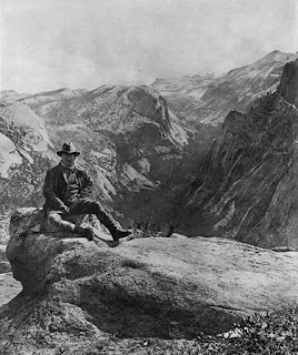
We began encountering famous trees, such as the Fallen Monarch that is famous for a picture of
Buffalo Soldiers from the 9th Cavalry standing on it about 100 years ago.
 |
| Compare this 2011 view to the black & white view below. |
The tree looks exactly the same as in the picture; only fire destroys these things. They do not rot. We then saw several other famous trees, including trees you can walk through. I was having a hard time matching the signage on the trails to the map in my hand, because neither one of these indicators seemed to match the reality on the ground. However, we had been on ground that had gently risen about 100 feet total form the parking lot, so it didn't seem like a very big deal. We found ourselves slightly off course from where I intended to be, but we encountered a sign saying "Museum 0.7 miles" and we decided to follow it. And we started walking up hill. And we walked up the side of a cliff. And then we turned a corner on the path, where we encountered an intersection for another path. The sign indicated that the "Museum" was still 0.7 miles ahead, even though we had walked at least a half mile uphill. So we continued on. And on. And on.
We encountered some folks coming down the path and we asked them if we were actually heading toward the Museum. They told us that we were, but that we still had a little bit of a hike ahead of us. So we continued marching up. Nothing on the map indicated the loops and switchbacks of this trail. Finally, we crested to a mountaintop meadow with a building that included some public restrooms. We were grumpy and angry about the incorrect signage and the obviously wrong distances. And then we walked beyond the building on a boardwalk path that led through a meadow that is Mariposa Grove.
Magnificence. Glory. Beauty. We were surrounded by a virtual ring of giant sequoias, with many more lurking in the background. The boardwalk through the meadow kept us out of the long grass but allowed us to be in the meadow. We simply stopped and stared for a long time. Mariposa Grove, despite the lousy signage, incorrect maps and crush of tourists at the foot of the Mountain, is an all-time great place.
 |
| Mariposa Grove. As Dylan croons on Standing in the Doorway: "No words need to be said." |
We visited the Museum (no stamp), found out that we couldn't catch a tram ride back down the mountain, and decided we would simply walk back down. How hard could it be? Well, we found out that the signage and the map were even worse on the way back down then on the way up (we attempted to go a shorter, more direct route to the parking lot on the way back down, but ended up walking down the middle of the mountain, and then diverting on a trail that actually took us to the loop trail on the edge of the Grove, and then finally down a logging road to the parking lot). Needless to say, we were thirsty, hungry, hot and fatigued when we got back to the car. We headed to the picnic area and had a lunch in which there was very little talking, but much scarfing of sandwiches, cherries, grapes and energy bars and much quaffing of water. Somewhat satiated, we piled back in the Tahoe and headed toward the other portions of Yosemite.
The first place we encountered was the Wawona area, with its grand turn-of-the-century hotel, broad meadow and a collection of 19th century structures. We stopped at the
NPS Information Station and found out that it really is a Visitors Center, so we got stamps, pins and postcards. This VC has one entire wall covered by a beautiful landscape painting of the Yosemite Valley.
 |
| All the Yosemite cancellations (and the stickers) are on the left hand page. |
 |
| Tim and Brian at Glacier Point |
We then headed for
Glacier Point. We drove north on the Wawona Road and then turned east on the Glacier Point Road. There was a lot of traffic heading back west as we headed in. We drove by Washburn Point and got our first view across the Yosemite Valley to
Half Dome, and then we made the turn toward the Glacier Point parking area, where you get a spectacular view if you don't drive off the curve, which has no guardrail. The parking area was packed, but we found a space toward the back, and then we walked up to the point. Glacier Point is truly a point, an apex of rock, so you have two different views.
 |
| East view from Glacier Point; Half Dome to the left, and Vernal (lower) and Nevada (upper) Fall to the right. |
One view is basically East, toward Half Dome, Nevada Fall and Vernal Fall; the other view is North toward Yosemite Falls with the camping and lodging areas of the valley below. We headed to the East view first; and it was amazing. We actually all kind of broke up as a group and observed the views on the clear, sunny day on our own. I peered across the Valley at the double waterfall of the Merced River made up of Vernal Fall (lower) and Nevada Fall (upper) and I shuddered. I knew that we had a hike to the top of Nevada Fall on our agenda for tomorrow morning; from Glacier Point, this ascension looked insurmountable. I saw people, tinier than ants at this distance, walking up the trail. I seriously doubted my ability to make this hike, but I kept my mouth shut and my fears to myself.
 |
The North view, showing the valley floor and Upper Yosemite Fall in the light, and Lower Yosemite bathed in shadow.
The point of rocks to the left is where TR sat as President of the United States. |
I wandered over to the other side of Glacier Point. I looked down into the valley and saw the white tents of Curry Village nestled into the forest directly below. I saw the
famous promontory rock that Teddy Roosevelt sat upon and had his picture taken; it makes my heart quiver just to think about it!
My brother Steve then wandered over and we had a good time spotting sites in the valley and taking pictures. Eventually, we made our way back to the book store (no stamp) where we bought tee shirts and various other souvenirs. We sat down outside the store for a moment, and then caught Tim, Brian and Pete returning from viewing the West side of Glacier Point. I have to say that we had all recovered our mojo after the problems encountered at Mariposa Grove. Everyone was enthused by the overwhelming beauty of the Yosemite Valley, along with the spine-tingling fear inspired by standing along the edge of these great cliffs of granite. We tumbled back into the Tahoe and headed back for our rendezvous in the Valley, where we would be spending the next two nights in Curry Village.
As we drove into the Valley, we encountered the beautiful views seen by millions of others and photographed by thousands, but we had to stop at the
Tunnel View parking lot anyway because of the gorgeous scene.
 |
| It really does not matter how many times you have seen pictures before; Tunnel View will take your breath away. |
We took many pictures of
El Capitan and various waterfalls; we took pictures of our whole group; we took pictures of young couples and solitary men on their cameras. It is a joyous friendly place, this Tunnel View spot.
 |
| The Stamp Guys at Tunnel View, with Brideveil Falls gushing. |
 |
| Pete is sobbing right now. |
We then headed into the valley, with its traffic and bicycles and shuttle buses, and followed the signs to
Curry Village. Steve and I got out after we parked in the registration parking lot, and then proceeded to experience one of the smoothest, easiest check-ins ever held at a campsite. Everything was organized and ready to go; the help was friendly and knowledgeable. Videos playing on monitors in the registration center showed the havoc that bears can wreak on cars in the Curry Village parking lot when less than all the food and toiletries are removed. We were handed the keys (yes, actual keys, not slips of plastic) to three adjoining two-person cabins. I had agreed to pay for one cabin on my own, while Pete and Steve teamed up in one and Brian and Tim in the other. By this time on the trip, we had designated Steve as Fiddler #2 (or F2) and the soul mate of Fiddler #1, our Rain Man Pete. Both Steve and Pete exercise their obsessions by compulsively fiddling with things; repacking their suit cases, organizing themselves for 10 minutes every time they get out of the car etc. It made sense to let them bunk together so they could drive each other insane and leave the rest of us alone.

We slung all our gear onto our backs and made a couple trips to get everything out of the Tahoe and into the cabins or the metal locking bear boxes outside each cabin. The cabins are white canvas with wooden floors and wooden superstructures; you feel like you're at a Boy Scout camp in Heaven. After getting settled in, I took a shower while the boys enjoyed a cold one at the cabins. We then headed into the Curry Village commissary area, where we took turns standing in line to order a couple of pizzas while the non-standers went into the bar and got tall glasses of
Mammoth Pale Ale for the group. As darkness descended on Curry Village, Tim found us a table to sit at, and Pete rigged up his flashlight under a Parmesan cheese shaker to form an excellent little lamp. Soon, the buzzer went off and Steve and Brian retrieved the pizzas. We ate and drank heartily, enjoying the camaraderie of the day and the excitement that seems to emanate from the ground in Curry Village.
Day 5: July 20, 2011
This day started for me at about 2:30 am, when I was awakened by a conversation between Tim and Brian in the cabin next to me. I couldn't believe that these guys were talking, or worse yet that they had never gone to sleep. It turns out that they both denied having this conversation when both Pete and I mentioned it to them at breakfast; either they're lying or it was some kind of mutual sleep-talking. Anyway, since I was awake and the beer was making its presence felt, I decided to walk to the bathroom and answer the call of nature. I grabbed my flashlight and threw on a pair of shorts and my tennis shoes and headed out. I locked my door, and then it hit me; I was walking outside, alone, in an area known for bears, close by the cabins and boxes where all the food is packed. I have to admit that I swung the beam of my flashlight widely as I peered ahead, to the sides and behind as I walked.
We got up early and headed to the commissary area for breakfast. There was a restaurant with a full breakfast smorgasbord, but it would not open for another hour, so we went to the ice cream/snack bar and grabbed some fruit, muffins and coffee. We had plenty of fruit, vegetables, beef jerky and Nature Valley bars for the morning hike, so the breakfast we got was substantial enough to sustain us for the strenuous work ahead. After walking back to our cabins, we geared up for the hike to Vernal Fall and then on to Nevada Fall, when one of our tent neighbors informed us that three people had died at Vernal Fall late yesterday afternoon. The details were sketchy, but it sounded like two children were posing for a picture above Vernal Fall and somehow slipped into the river, and that a bystander who attempted to save them grabbed them but was pulled over the Fall with them (we would later find out that the story was much different, and fit into the garden-variety SCE we had been seeing all week). The man who told us the story was planning to hike to Half Dome, and he told us that the Mist Trail along Vernal Fall had been closed yesterday after this incident, and that he didn't know if it would be open this morning. We headed to the shuttle bus stop and took the short shuttle ride from Curry Village to Happy Isles. I asked the driver if he knew whether the
Mist Trail would be open, and he said "That thing is like a superhighway; it will have to be open." As we exited the bus, a man walking to the Nature Center at Happy Isles told us that an alternate trail (which he called the horse trail) would be open to take us to the top of Vernal Fall, and that we were actually lucky because it was easier than "climbing up blocks on the Mist Trail."
 |
| Pete's comment: "Let's go to Whitney." |
With these slightly mysterious words ringing in our ears, we hit the trailhead at Happy Isles and began our ascent. The trail starts off as asphalt heading South, and gradually rises from the valley floor as you walk along the Merced River. Soon, you begin to turn toward the East and you see Illilouette Fall across the valley as you rise above the rushing sound of the crashing & gnashing Merced. We then dropped down about 50 feet to a bridge over the Merced, with a great view of
Vernal Fall framed in the open area above the roaring water. After we crossed the river, we saw that there was yellow police tape across the entrance to the Mist Trail.
We then took the alternative trail to Clark Point. This trail involved MANY switchbacks up the side of a tree-covered cliff. This trail was interesting because you really couldn't see how high you had to go on the cliff. In addition, we could hear the roar of Vernal Fall at the beginning of the hike, but then lost the sound as we ascended. As we climbed higher, we began to get amazing views: first, the double glory of Upper Yosemite Fall and Lower Yosemite Fall presented themselves in the distance back west down the Valley.
 |
| Resting at the top of one of the countless switchbacks. |
 |
| Pete at Clark Point, with Nevada Fall. |
Later, as we turned a curve in the path, Half Dome appeared before us. We rested briefly from time to time to take pictures and catch our breath, but continued to make steady progress up the path, and then we finally came to the top of the cliff, emerged from the trees and encountered a three way path junction on a flat piece of rock. This, we learned from signs, was Clark Point. Ahead of us, we could see a large waterfall at our level, which I naturally assumed was Vernal Fall, along with three very small waterfalls spilling over the cliff near the large waterfall. One of the paths descended down into the river valley.
The other path (which we noted was part of the John Muir Trail) turned off over the rocks to the right. We stopped and had a snack and talked to some people coming through the path, and I was surprised to find out that we had climbed all the way past Vernal Fall, and that the waterfall I saw on our level was actually
Nevada Fall. I was happy and proud of our group; we had basically climbed up 1900 feet (starting at 4000 feet) in a few hours, and we were not anywhere near exhausted or wasted.
 |
| Brian walking through snow melt on the John Muir Trail. |
We then took the John Muir Trail "up" to Nevada Fall rather than back down into the Valley; none of us wanted to give up the altitude we had gained simply to have to climb back up. The John Muir Trail was really neat; it continued generally east and slightly uphill through an open, rocky area, and then turned northeast along the top of the shoulder of the mountain that was bisected by the Merced as its contents spill over Nevada Fall. We really began to experience the snow melt as the day heated up along this portion of our hike. We crossed numerous small streams that created the mini-waterfalls over the side of the cliff south of Nevada Fall that we had spotted at the Clark Point trail junction. At one point, the path narrowed as the wall of the mountain on our right came close to the path, and water dribbled down the side of the hill, providing a very cold shower that was difficult to avoid.
 |
| Liberty Cap towers over Nevada Fall. |
As we began to hear Nevada Fall, the trail began to descend slightly and we entered a wonderland of beautiful trees and great little streams carving through the forest undergrowth, pooling and tumbling toward the Merced. We then emerged onto a granite plain at the edge of Nevada Fall, with a wooden bridge over the Merced set about 25 yards upstream from the Fall, all overshadowed by the dark rock of Liberty Cap, an unbelievably beautiful granite dome. Pete crossed over the bridge and began exploring, while Steve and I took a seat on a convenient boulder and waited for Tim and Brian (who had stopped to take photographs) to catch up. As we waited, Steve and I observed two joggers approach the Merced from the trail on the other side of the River (which leads on to Half Dome). These joggers actually crossed over a railing and walked into the pooling water of the river about 60 yards upstream of the fall, and began scooping handfuls of the icy stream over the heads and into their mouths. When Tim and Brian came up and the four of us crossed the bridge, Steve pointed out a sign on the railing that said "If you go into the water, you will die" right where the joggers had decided that they needed that cool elixir. SCE.
 |
| Steve and Jamie take a breather after getting to the Merced River at Nevada Fall. |
 |
| 4 Stamp Guys at the top. |
We then scrambled over the granite cap on the northern edge of Nevada Fall and dropped down to a viewing area where you can look straight down at the water tumbling into the valley below. We took pictures and soaked in the view. We ate our packed brown bag lunch, lounging on the rocks. We observed people hanging off of trees and balancing precariously on slippery rocks at a 45 degree angle, simply to get a picture showing themselves near the edge of Nevada Fall. We shook our heads at the SCE. After about a half hour rest, we decided to head back down. We were all feeling great and excited for the remainder of the afternoon in Yosemite Valley. I assumed that the trip down would be much easier than the trip up. I assumed incorrectly.
 |
| The Bridge across the Merced. |
 |
| Note the last sentence of the large type. |
 |
| The Merced rushes over Nevada Fall; view from the Bridge. |
 |
| Looking down over Nevada Fall. Stamp Guy Mike will never see this site. |
 |
| Note all the heads down as we try to avoid slipping. |
As we headed down, we encountered an issue that had not troubled us on the way up. The wet rocks of the John Muir Trail now were sinister as you walked along the edge of the cliff with your weight creating unwanted momentum.
After Clark Point, we noticed that the pumice-like dust on the trail was very slippery as you stride down the path, causing each of us to pick each footfall carefully. By the time we got to the base of Vernal Fall, all of us were surprised at how physically draining the trip down had been (well, maybe not Pete).

However, we now noticed that the Mist Trail up to Vernal Fall was open, and we saw signs stating that that it would be a hike of only about 0.3 miles from this point. Pete and Brian wanted to go up the Mist Trail; I had used up the last of the water in my camelback, and Steve wanted to answer the call of nature. Tim cast the deciding vote and we headed up the Trail. The Mist Trail goes up next to the water of Vernal Fall, so you are actually in the mist. The first part of the trail was an asphalt path going up at a steady but not overwhelming angle. We began to notice that the Trail was very busy; many people were walking up with us, but even more people seemed to be coming down the path. Many of these latter folks were quite wet. There also were a lot of small children, some perched precariously on their Dad's shoulders, but many running around. The Trail soon turned into a series of stone steps, and the mist from Vernal Fall began to make its presence felt. The farther we went up, the tighter (and wetter) the Trail became. Soon, we were jostling shoulder to shoulder with fellow hikers on the way down the path, with no guardrail between us and the roaring water tumbling down next to us. Tim then tapped me on the shoulder and told me that Steve had turned back. I continued up the increasingly more difficult stone steps, which by this point on the Trail were thoroughly soaked. I saw that the Trail made a sharp turn to the right just ahead, and presented a magnificent view of Vernal Fall at that point. I stopped to admire the view, but had to keep moving around to allow other hikers to pass me. Then, a small child (probably 5 or 6 years old) slipped as he came down the path and crashed into me. I had to reach out the grab the wall in front of me; but it made me very concerned. What if this happened where there was no wall or railing? What if I slipped, and my 255 pounds of bulk knocked into a small child? I told the other guys that I was turning back.
 |
| Not for the faint of heart. |
As I was heading back down, the chaos continued, with people bumping into each other on the slippery stones next to the raging waterfall. One particular idiot earned my wrath: he was a man about 60 years old, thin & fit, who had passed me on the way up the Trail, using two ski-poles to assist his fast gait as he weaved in & out of the heavy traffic. Now, on the way down, he passed me again, and thrust one of his stupid poles in front of me just as I was stepping down onto a slick stone step. No look back; no attempt to apologize; just an idiot treating a crowded, dangerous Trail in a National Park as his personal work out space.
 |
| Tim on the slippery blocks of the Mist Trail. |
I soon met up with Steve, and we refilled our water containers from a fountain at the bridge over the Merced River. Soon, the other three Stamp Guys joined us; they had all turned back before reaching the top because of the increasingly dangerous conditions on the crowded, wet trail. We then set out to walk the asphalt path back to Happy Isles, which is actually quite steep and was hard work to walk down (at least for me). As we got about a quarter mile down the path, Brian caught up to Pete, Steve and me and told us to stop. Tim was getting interviewed by a local TV news crew who was making a story about the deaths at Vernal Fall the previous day. Tim caught up to us several minutes later, and we razzed him for being a publicity-seeking pretty boy, and he told us about the interview as we continued pounding down the path. Finally, we bottomed out and wandered the short distance to the Happy Isles shuttle stop, where thankfully a shuttle appeared quickly. We all sat in the shuttle, pretty mum from fatigue, and then got out at Curry Village and trudged back to our cabins. I was soaked through with sweat, and told everyone I had to take a shower. No one wanted to take off on another difficult climb, so we decided to rest & recuperate for a few minutes before getting lunch and then heading over to the Yosemite Visitors Center.
 |
| The news crew that interviewed Tim-I-Am |
I felt a little better after the shower, but much better after we got our lunch from a Mexican taqueria in Curry Village. We then took the shuttle over to Yosemite Village, where we hit the Visitors Center and the Post Office (the Post Office had some great tee shirts based on historic postage stamps featuring Yosemite, and I bought the version featuring El Capitan on a one cent stamp). We then decided to take a shuttle to El Capitan, but when we got on the purple shuttle, we found out it would stop running in a little under an hour after dropping us off. Several of the Stamp Guys became concerned that we might get stranded in the far western reaches of the Valley and then have to make the long hoof back to Curry Village if we missed the shuttle, so we changed plans on the fly and simply rode the purple shuttle back to Yosemite Village and then caught the green shuttle to the Lower Yosemite Fall trail (other than Steve, who decided to skip another hike and headed back to Curry Village on the green shuttle).
 |
| Upper & Lower Yosemite Falls |
The remainder of the group got off at Lower Yosemite shuttle stop and wandered with masses of humanity up the broad, flat asphalt trail (more like a superhighway) to the Fall. We enjoyed the beauty of the site, which you view from the foot of the Fall. We also caught many nice views of Upper Yosemite Fall during the walk. We discussed how different the vibe was on at this site than on the trail to Nevada Fall; here, you had generations of families strolling together, and lots of loud somewhat boorish behavior. It definitely is a site open to anyone, no matter your age or health condition.

After witnessing more clownish behavior at Lower Yosemite Fall (including a Japanese man trying to drag his bride-who was wearing a long skirt and impractical shoes-down into the rocks where the stream flows from the bottom of the Fall), we took a leisurely walk back to the shuttle stop. We decided that we had time to get back to Curry Village, pick up Steve and head to a one-person stage play in the Yosemite Valley Visitors Center theatre on the life of John Muir, and so we did. The show was interesting because it showed that Muir was not a saint; he HATED hikers and others who simply came to glimpse these wonders; he wanted to preserve the High Sierra for those who passed his puritanical view of worthiness, which basically meant you had to live out there and commune with the rocks. After the show, we headed back to the food area at Curry Village, and were literally the second to last group to get in line at the last open food commissary. We ordered our dinner, and then sat down and enjoyed some beer while waiting for the grub, which came out fairly quickly. We then planned to get up at 7:00 am the next morning so we could get the breakfast smorgasbord before heading onto the Tioga Road and into the High Sierra of Yosemite.
 |
| The base of Lower Yosemite Fall (yes, those tiny figures are people). |
Day 6: July 21, 2011
We slept in a little longer this morning than we had all week, and the extra rest seemed to help. We ate at the smorgasbord breakfast in the Curry Village restaurant area, and then packed the bags, loaded up the Tahoe and headed out of the Yosemite Valley. We entered the famous Tioga Road in a little while, and then headed east toward the High Sierra. We soon began to note the changes in the landscape as we climbed from 4000 feet toward 8000 feet; the trees began to thin out, and the mountains became more bare and rugged. We stopped at a viewing area called Olmstead Point (named after
Frederick Law Olmstead, Jr.) which had spectacular views back toward Yosemite Valley and the rest of the Yosemite wilderness. We were able to see the "other" side of Half Dome, and through Steve's binoculars we spotted the tiny figures of climbers working their way up the famous peak. The mosquitoes were ubiquitous at Olmstead Point, but seemed to be lethargic and easy to kill. Nonetheless, they were pretty aggressive.
 |
| The "backside" of Half Dome, as viewed from Olmstead Point on the Tioga Road. |
After killing the few mosquitoes that entered the Tahoe, we headed east to Tuolumne (pronounced "Too-Owl-O-Me") Meadows, where we pulled into a parking lot below a rustic-looking Visitor's Center that turned out to be a CCC construction project during the 1930's.


As the group did the normal VC routine of stamps, pins and postcards, I talked to a young female ranger about the hikes we wanted to take. We wanted to be able to get to the Mono Lake Visitors Center before it closed at 5:30 pm, and we wanted to take a hike in the Meadow and another hike up to a mountain lake. We had tentatively agreed to hike the Pacific Crest Trail from
Tuolomne Meadws to the Twin Bridges area in Lyell Canyon, and then had identified a hike from the Tioga Pass to Gaylor Lakes. The Ranger agreed with me that we could get both hikes in and have plenty of time to get to Mono Lake. She told me that we would encounter some snow on the Gaylor Lakes hike, and when I told her that we were from Ohio and had no problem with snow, she enthusiastically congratulated me (and, by implication, the Stamp Guys) for being willing to take these two great hikes. I gathered up the boys, and then we headed down to the car to gear up. Tim and I used a convenient large rock next to the parking lot as a table to make sandwiches for our lunch to be eaten on the Pacific Crest Trail, and then we drove east for a couple of miles to the parking area for the trail to Dog Lake, where the Pacific Crest Trail crosses the Tioga Road.


We too crossed the Tioga Raod and set off on a fairly level trail through a beautiful meadow. The trail stayed fairly close to the road for a couple of miles, and then turned south where we crossed a creek on a wooden bridge. We were still within our time window, so we followed the trail south toward the area marked as Twin Bridges on our trail map. This portion of the hike was through forest and some fields of granite, always ascending slightly. After climbing through several different fields of smooth granite, we came out into another meadow, and the world seemed to open up before me.
 |
| The meadow at Twin Bridges. |
Many large, flat rocks stood before us at the confluence of two creeks, smoothed by eons of water washing over and through them. The water moved smoothly through this junction, even though it was flowing very fast. Two small wooden bridges crossed the creeks at offset angles to each other, which gave the whole confluence area a feel of freedom; man adapting to Nature's contours, and not vice versa. Surrounding the bridge area, green meadow stretched to the base of mountains on all sides, and these gray behemoths were capped with brilliant mantles of white snow. The white of the snow contrasted sharply with the blue of the cloudless mountain sky. Twin Bridges may be the most beautiful place on the face of the Earth; it is certainly the most beautiful place I have ever seen.
 |
| Some handsome guys in a beautiful place. |
 |
| Steve and Jamie "walking in beauty" as the Navajos say. |
We took a number of pictures, trying to capture the serene splendor. Fellow hikers cheerily joined in conversations of the glories of this High Sierra wonder spot. We then moved to a rock outcropping shaded by cedar trees along one of the creeks, which quickly turned back into a white water-laced beast as it emptied out of the confluence area, and we ate our lunch. After a brief rest, we headed back from whence we came, spotting deer in the meadows along the way, and then tumbled into the Tahoe for a 15 mile ride further east to Tioga Pass, the trail head for the Gaylor Lakes Trail.
 |
| The Ranger Station at Tioga Pass. |
When we arrived at the Tioga Pass Ranger Station, we had to parking illegally in a striped space because all the other spaces in the lot were taken, and signs told us we would get our vehicle towed if we parked on the road. I checked in at the tiny ranger station (no stamp), and a young female ranger told me we were fine where we parked. I asked her where the trailhead was for Gaylor Lakes, and she had no idea. She walked outside and asked a Ranger who was manning the entry gate into the park (ie collecting fees), and he pointed back to the other end of the parking lot. I met the boys as they emerged from the rest room, and we headed to the trailhead and began climbing.

The trail soon became a very steep walk up the side of a mountain. People coming down the trail told us that the trail went basically straight up, climbing over 500 feet, before it leveled out at a mountain saddle. Pete of course had no problems ascending and easily could've walked all the way up without a break, but I couldn't, so we decided to take a break at about each 50 feet of elevation gain. This worked well as we struggled up from 9950 feet at the Ranger Station to the 10,500 foot level of the saddle. We saw patches of snow on the way up, and were confronted by a large field of packed snow at the top of the trail as it emptied into the saddle.
 |
| Stamp Guys at 10,000 feet (thus the hand gestures). My walking stick is the "1". Pete is disgusted. |
 |
| Tim glancing back and Brian trudging on through the snow at the top of the Gaylor Lakes trail. |
 |
| Snow-covered Gaylor Lake on July 21, 2011. |
We were able to skirt around the hard snow, and then below opened a valley dominated by a large lake, blue in places but mainly still covered by snow and ice. I decided to stay up in the saddle and rest and Steve decided to stay with me, but Pete, Tim and Brian walked down to the lake.
 |
| Mount Dana and Dana Meadow. |
 |
| At the top of the Gaylor Lakes trail (with Mt. Dana looming), the Stamp Guys hit 10,500 feet. Steve is not an Egyptian. |
I recovered my strength by the time those three climbed back up to the saddle, as I enjoyed the view of Mount Dana and the beautiful Dana Meadow at its feet, which looked like a golf course from our high vantage point. We then headed back down the trail, which wasn't nearly as difficult as I thought it was going to be (maybe because I had rested and renewed my strength). We hopped into the Tahoe, and headed east out of Yosemite (after answering a Ranger's trivia question at the gate--Where was the TV show
Twin Peaks filmed?-- which certainly was in the bailiwick of this group), and then had a great drive down the Tioga Road to Lee Vining, California, where we turned north for the short jaunt to the Mono Basin Scenic Area Visitors Center. This drive has many great sites, but there is one view that is absolutely spectacular, as the last mountains of the Sierra Nevada range part, you look down on Mono Lake and then the White Mountains beyond, framed in the "V" of the Sierra's. WOW!
The VC at Mono Lake is run by the Forest Service, and they have two stamps (see the lower left corner of the page with the Yosemite stamps above): one is a duck that would not work, but the other is a cool type of dial. The VC had a large book store and a good museum on the peculiar habitat created by Mono Lake, and its history within the water rights feuds of California. Outside, there is a viewing platform with good descriptions of the various features of the Mono Lake region, including a volcanic crater that erupted in the 1500's and created the youngest mountain in America, and the peculiar Tufa formations (which look like tall windpipes out of a Dr. Seuss book).
 |
| The stone formations are Tufas at Mono Lake. |
 |
| Panum Crater, the youngest mountain in America. |
We decided to go to Panum Crater, the youngest of a series of mountains called the Mono Craters, created by a series of volcanoes in the the time frame from the 1300's to the 1500's. We drove down a dirt road surrounded by juniper and sage plants, and we commented upon the unbelievable change in scenery from the Alpine environment of the High Sierra to this desert-like environment, within a handful miles of each other.
At the end of the dirt road, we got to a parking lot and walked up a trail to the lip of Panum Crater (yes, we climbed yet another mountain, albeit one that started a lot closer to sea level than we had been climbing all day). Panum Crater was hot, dusty and bereft of any green foliage, and the inside of the crater looked like a child's room after friends come over to play; a chaotic mess of boulders, dirt slides and dust. It looked young; not much smoothing by weather has occurred inside the crater. However, the hot environment was not very enticing to our mountain-spoiled bodies, so we left the area after a fairly short visit and got back into the trusty vehicle to visit the South Tufa area along Mono Lake.
 |
| Looking down into Panum Crater. |
This site is touted as having the best collection of tufas, and I think the Forest Service is right. Tufas are formed underwater; the reason you can see so many tufas at this site is that Mono Lake lost a lot of its water by being diverted to Southern California. However, lawsuits in the 1980's stopped the drainage, and the Lake is slowly returning to its former size. The Forest Service explains all of these facts to you with excellent signage along a path from the parking lot to the lake shore at this South Tufa site. They even have marked where the edge of the lake will be when the court's order is fully implemented, and where the lake's edge was in 1948. Many of the tufas you can see today will be covered by water when the court's order is satisfied. The signs also explain that 80% of the seagulls in California come to Mono Lake to hatch their young. We witnessed a vast throng of young seagulls, monitored by less than ten adult birds, as they paddled around the lake. We got to see this large brood take evasive actions when a kestrel appeared in the distance, pin-wheeling across the lake and looking for any strays. The young birds moved as if they were connected by one vast brain, turning and speeding up simultaneously as the adult birds shepherded them. It was really amazing.
 |
| Tufas to the left and baby gulls in the water. |
 |
| A tufa formation in Mono Lake, surrounded by baby seagulls. |
The path also takes you through fields of juniper bushes that grow tightly packed together at waist height. This place must smell like heaven when it rains. We completed the loop path back to the parking lot with lots of compliments for the excellent display of this site by the Forest Service, including signage on the unique water concentration (which is very salty so no fish can live in the lake), the snails that serve as a food source and the sand flys that can swim underwater for long periods without breathing air. Interestingly, this site had a lot of visitation (despite charging a fee) while nearby Panum Crater was virtually deserted.
 |
| Steve and Brian among the Tufas. |
We then headed for the Juniper Springs Resort at Mammoth, California, which would be our harbor for the evening. After checking in to our large suite with two bedrooms (Brian got the couch), we showered and then headed into the resort town for dinner at one of Pete's pre-scouted places. We sampled several varieties of micro brews on tap, including a Tower 14 IPA that was very good, and ate hearty combinations of steak and fish. We called it a fairly early night, and I fell asleep the moment we made it back to the hotel.
Day 7: Friday, July 22, 2011

In the planning for the Bear Republic Review, Phase I, this is the day that gave me the most concern. We had three major sites to cover (Devils Postpile National Monument, Ancient Bristlecone Forest State Park and Manzanar National Historic Site) along with long drives in between, and then a long drive into Death Valley to the Stovepipe Wells area. We therefore agreed to start very early, which would involve us getting into Devils Postpile before the park "opens" and getting our stamp on the way out after we have seen the sites. Since we awoke so early, the restaurant in the Resort was not open, so I got directions (the night before) to a coffee shop in town. We got to the shop right at 6:00 am, had a quick cup of java and muffins, yogurt & granola, bananas etc. and then hit the road for the short (but exciting) drive into Devils Postpile National Monument. This road is serpentine and (of course) winds along the edge of a cliff as it descends into the valley that contains the Devils Postpile formation. Luckily, there was no traffic at this time of the morning, because the road is rarely more that 1.5 lanes wide (but there are some infrequent turn outs); this is why only shuttle buses are allowed into the Park after 6:30 am.

We drove down into the valley and parked at the Ranger Station parking lot, where we geared up for a hike to the formation and then down to Rainbow Fall. The morning was cool in the valley, and we wore jackets as we started out. We saw a deer ahead of us on the path, and enjoyed the slightly downhill trail. Soon, we encountered wayside exhibits that explained that the Devils Postpile formation actually was part of Yosemite at one point in time, and then was transferred to the Forest Service in the 1905 under pressure from mining interests. The Park Service got the area designated as a National Monument by William Howard Taft in 1911 when the Forest Service announced that they were going to consider a petition to blow up the formation. It made us laugh; a classic wayside where bureaucrats tee up their derision of fellow bureaucrats. I should note that the NPS website does clarify that the Park Service rejected the plan to blow up Devils Postpile.
 |
| Devils Postpile. |
We passed Soda Springs (a spring of carbonated water, for God's sake) and then came upon the rock formation called Devils Postpile. This rock formation was formed when lava from a volcano pooled in the valley, forming a lava lake that eventually cooled into a solid rock formation, which then "fractured" into hexagon-shaped pillars that are tall and thin and stacked next to each other like pieces of spaghetti in a box of vermicelli. As the outside edge of the formation got exposed by the passage of a glacier, the pillars began to weather and fall, exposing the next layer to the inside which would also weather & fall, etc. There is a pile of tumbled rock pillars at the bottom of the formation, but they look like the columns from a Roman temple in their uniformity. In addition, the edges of the exposed rock formation are twisted, and they almost look like paint strokes from oil paint. The geological story of this unique formation is fascinating, and the longer you spend time there, the more mesmerizing the place becomes.
 |
| The Joaquin River from the Stock Bridge on the Pacific Crest Trail. |
 |
| At the end of the Stock Bridge. |
However, we had a long day ahead of us and we reluctantly pulled ourselves away and continued heading south toward Rainbow Fall. Our path intersected with both the John Muir Trail and the Pacific Crest Trail near the Stock Bridge, where these two famous trails cross the Joaquin River. We continued down our path, descending along with the Joaquin as it makes its winding route south, and then northeast, and then south again. As we walked through the area around Boundary Creek we entered an area that had been devastated by fire. We were amazed to find out the fire happened 19 years ago; it looked like it happened last year. There was much good signage describing the cause of the fire (lighting strike far to the south), the reasons it roared through the valley (lack of controlled burns over time) and the amazing effect it has wrought (new flower, plant and tree species, and the reintroduction of various wildlife that could not survive in the choked mature forest that burned away).


As we walked through the large burnt-out area, we left the National Monument and entered the Ansel Adams Wilderness, part of the Inyo National Forest. Soon we saw the signs for the side trail to
Rainbow Fall (by the way, this is a link to videos created by Steve on his awesome Android phone), and we crossed the border back into Devils Postpile National Monument. We approached this Fall from above and from the East, which allowed us to see its most famous aspect as the morning light poured over our shoulders and illuminated the mist of the Fall into numerous rainbows. We sat and rested at a viewing area just below the top of the Fall, getting some great pictures and munching on energy bars.
 |
| Rainbow Fall (Upper) in Devils Postpile National Monument. |
 |
| The Stamp Guys at Rainbow Fall. |
 |
| Jacket unzipped, I rest for the walk back to Reds Meadow. |
However, the inexorable clock ticking in my head would not let me let us rest for long, and soon we were hoofing uphill out of the area of the Fall. Our plan was to hike to the Reds Meadow Resort Area, where we would catch a shuttle bus back to the Ranger Station in an attempt to save the time of the walk back up the valley. Pete set a steady pace uphill, and something miraculous happened to me. Maybe it was all the hiking this week on top of my pre-trip training; maybe it was that I finally was acclimated to the thin mountain air, or maybe it was because we were not at 10,000 feet elevation, but I COULD STAY UP WITH PETE. We hiked steadily uphill, and my fellow Stamp Guys had to call for brief halts from time to time. We emerged onto the plateau next to some horse stables at Reds Meadow, which was a neat little cluster of A-framed cabins, a general store, a diner and the horse stables clustered into an open plateau on the side of a mountain.

We had removed our jackets as we worked hard on the climb up to this interesting place, but we soon began to cool down and the crisp air caused us to re-don the jackets. A shuttle bus showed up after about a 20 minute wait, and the driver told us we would have to wait about 8 minutes to leave. I fretted about my plan; maybe we would have been better off hiking all the way back to the Ranger Station. However, the shuttle driver was one of those guys who basically lives in national parks, taking various summer jobs to support his obsession, and we soon were in a great conversation about Devils Postpile, Yosemite, SCE etc. The driver congratulated us on our plan of driving in early, and told us that we had seen the sites the "right" way. We felt great to get this affirmation from a pro.
 |
| A great wayside on the Rainbow Fire's effect on Reds Meadow. |
 |
| Awaiting the shuttle outside the diner in Reds Meadow Resort. |
 |
| "Release the Crack-en" |
By the time we got to the Ranger Station, the Station was open and we were greeted by a very friendly park volunteer named Frank. Frank talked to each of the Stamp Guys as we milled around inside & outside the small Ranger Station, getting our pins, postcards and stamps. The stamping station is actually set up outside the Ranger Station on the porch. There are two stamps: one for the 25th anniversary of the stamp program, and then the regular stamp (see the right-hand Passport page at the beginning of the Yosemite entry of July 19 above). 2011 is Devils Postpile's centennial as a National Monument, so I bought the pin celebrating that fact. Soon, a shuttle arrived and disgorged a full load of tourists, and we knew it was time to get out of the valley. We stopped at a site in the Inyo National Forest on the way out of the Monument called "Earthquake Fault." If was a cool crack in the ground, even though there is now significant doubt whether it was caused by an earthquake (according to the wayside exhibit at the site).

We then hit the road; well, after we stopped at the post office in Mammoth to mail yet another parcel of postcards. (What hath I wrought?) Then we hit the road and headed south through the wide Owens River valley that flows between the majestic Sierra Nevadas on the west and the White Mountains on the east. We made good time, with only one short stop for petrol, pop and potty (the three P's) at Lone Pine, California. Soon, we saw the Inyo National Forest Ranger Station south of Bishop, which is where we turned off for the drive east and back north into the White Mountains to the Ancient Bristlecone Pine Forest. The Travel Section in the Sunday Edition of
The Columbus Dispatch (my hometown newspaper) is excellent, and had run a feature on this Forest park in March shortly after our first planning session for Phase I of the Bear Republic Revue, and we had all enthusiastically agreed to add this site to our trip. Brain drove as we climbed up on a county road before turning onto a gravel Forest Service road that would take us 26 miles to the Visitors Center at Schulman Grove, which sits at 10,000 feet. We got there all in one piece, and the spectacular blue sky framed rugged mountains that were covered with thousands of Bristlecone Pines, the oldest living things on the face of the Earth.
We listened to a Ranger talking to a few folks at a picnic table in the parking lot, and then realized that he had interrupted his own lunch to speak effusively and at great length about the Bristlecone Pine. He showed us how each tree actually has male and female reproductive parts. He showed us "this year's" pine cones, and the cones of previous years hanging on the tree (the cones sprout small prickers, thus earning the sobriquet for the species). As he seemed to be gaining steam (rather than trying to get back to his lunch), we slowly slipped away one-by-one and headed into the trailer that serves as the Visitors Center. The previous VC was burned down by an arsonist who was trying to get back at George W. Bush for planting a chip in his head. I'm not kidding. Even worse, the guy was sentenced to a very short prison stay and is already out, even as the new VC is still in the process of being built by a live-in crew in the summer of 2011. It's no wonder that so many Americans hold us lawyers and our profession in such low esteem when this obvious miscarriage of justice results from time to time.
However, the young female Forest Service employee, slim and somewhat mysterious behind her Wayfarer sunglasses, was very knowledgeable and discussed the situation in a distant, clinical manner, only slightly tinged with cynicism. We got a very cool stamp (see the Kings Canyon page of stamps above) featuring a gnarled Brsitlecone. Brian and I bought wicking tee shirts with a huge bristlecone on the back. We grabbed a trail map and headed out. On the way to the park, we had decided to take the 1.1 mile Discovery Trail, rather than the 4.5 mile Patriarch's Trail that goes by the unmarked Methusela Tree, the oldest living thing on Earth at 4,777 years old. I was still concerned about our time budget, and I really wanted to get to Manzanar with plenty of time to experience the site. We figured that we could not really claimed to have seen the Methusela Tree since it was unmarked anyway, so we might as well go for the shorter trip.
 |
| A young bristlecone pine tree. |
For some reason, my expectations of this park were fairly low; maybe I have become such a National Park Service snob that I don't think anyone else can administer and present a park the right way.
 |
| Sign describing the Arson of the VC at the Ancient Bristelcone Pine Forest. |
As we started climbing the Discovery Trail, I quickly was disabused of my low expectations. One of the first waysides we came across was set up at a dead bristlecone. We learned that the dead wood is impervious to any sort of rot or insect action, and that only fire destroys them, and that many of the dead bristlecones in the Park were over 4000 years old! There was also a convenient cut off portion of the dead tree, allowing you to inspect the microscopic rings added each year during these trees' incredibly long lives.
 |
| Brian, Steve and Pete inspect the rings of a dead tree. |
 |
| Wayside that started the Madness. |
A subsequent wayside explained how
Dr. Edmund Schulman and his assistant came to this remote region in 1954 based on a rumor that there were old trees here. In 1957, they discovered Methusela, and published their findings in
National Geographic in 1958, but only after Dr. Schulman died at the age of 49. This set of facts somehow became the source of a comedy routine between Steve and Brian, in which the role of the assistant was played by Jerry Lewis, who would shout out Dr. Schulman's mother's phone number every time Dr. Schulman's ring count got above 4000, or who would rearrange the good Doctor's sock drawer and find compromising materials whenever Dr. Schulman sent him away. Steve and Brian would effortlessly swap the role of Dr. Schulman and his goofy assistant as they continued to spin out the routine. It was giddy and ridiculous, but it had us all laughing uproariously as we made our way higher up the trail (and then it reappeared sporadically during the remainder of the trip, usually when someone counted something or anyone mentioned a bristlecone pine).

After climbing about 250 feet, we saw a wayside that explained the view of the Sierra Nevadas to the west, where they loomed like skull-capped heavyweight Belgian monks, silently brooding over their wort. Two elderly ladies were also taking in the view; when one of them commented "What a beautiful view" our man Tim said "I've seen better" with a perfectly straight face and walked away, leaving the sisters with mouths agape. Maybe the thin air made the comedy bug bite so hard.
All this mirth made the climb up to 10,600 feet pretty effortless, and we kept seeing larger and more interesting trees. Then, the Rain Man came up with a brilliantly conceived conspiracy theory: the Methusela Tree is actually
on the Discovery Trail, and not on the other, longer tail, and that the misdirection by the Forest Service is deliberately designed to throw the uninitiated off the track. Pete reasoned that the Discovery Trail is right next to the VC, which is usually placed at the most important point in a park, and that the very name "Discovery Trail" was a clue for worthy to unlock this mystery. We all happily agreed to this analysis, and began picking out our own private Methuselas.
 |
| Methusela???? |
 |
| Pete on the trail through the pines. |
At the top of the trail, the path led out of the forest and into an area bereft of most foliage and with red rock as the ground, rather the soft brown dirt of the other side of a trail.
 |
| Note the dramatic change in the landscape along the edge of the forest. |
A Forest Service wayside explained this striking difference in geology based on events that happened millions of years ago. We then continued down the trail and eventually re-entered the bristlecone pine forest, and soon found our way back to the parking lot by the VC, where that same Ranger was still expostulating in the parking lot, his forsaken lunch sitting uneaten on the picnic table.
 |
| Steve, Pete and Brian on the red rock portion of the Discovery Trail. |
We enjoyed the views of the Sierras and the White Mountains on the drive back down to the valley, and we all agreed that the Ancient Bristlecone Pine Park is a GREAT place and deserves visitation. We were amazed at how many people made the long drive up the rough roads to get there; it definitely attracts a lot of people on a warm summer day.
 |
| Tim can take one hell of a picture. |
We then made a beeline south through Independence, California for the Manzanar National Historic Site. We arrived at a hot, dusty plain with a large peak of the Sierras towering off to the west as we encountered the famous brown NPS signs announcing that Manzanar was just ahead. And then we saw a guard tower. And then we were directed through gates that faintly resembled pagodas, and then we looped along roads that passed an abandoned village with signs like "Newspaper" and "Police Station" where buildings used to be until we entered a parking lot outside a large, hanger-like structure.
A wayside explained that this building was the auditorium of the town of Manzanar, and that it is now the only remaining original structure from the WWII era. It also serves as the Visitors Center. There was an old-fashioned fire truck parked outside, which signage told us was one of the engines used by the Manzanar Fire Department during the War.
 |
| A guard tower, with the auditorium/VC in the background. This picture really captures the tragedy of this place. |
Before I go further, I want to add two editorial comments. First, the Stamp Guys actually toured the Rohwer (Arkansas) War Relocation Center State Park during our May Civil War trip; Stamp Guy Mike is still working on that entry, but suffice it to say that it was a sobering thrill to visit that place, and it whetted the appetites of Tim, Pete and me to get to Manzanar to see a more fulsome display of the Japanese internment saga. Second, and more importantly, I am immensely proud of the National Park Service for telling this story (which certainly does not reflect our finest moment as a nation) in such a compelingly nuanced manner, and not in some knee-jerk, politically correct "let's blame those idiotic Americans of the 1940's" way.
We started out in the book store, where the stamping station is located (a picture of the Manzanar Stamp and cancellation is way back up at the Day 4 entry on Yosemite). A very friendly, knowledgeable ranger greeted us and told us when the next movie would be shown. He enthusiastically promoted the movie, pointing out that it included the voices of only those who actually were interned in Manzanar. As the Stamp Guys wandered through the large book store, buying pins, postcards and tee shirts, the Ranger inquired about what brought five Midwestern guys to Manzanar on a Friday afternoon in July, and we told him about our trip. He was very interested to hear our opinions on how the various National Parks were performing this summer, and so we told him how we felt about the Mist Trail and the lousy food at Grants Grove, and how much we loved everything else. We spent a few minutes starting to look through the expansive museum, and then heard the PA announcement for the beginning of the movie, so we hustled over to the theatre.

The movie was impressive, and explained how Japanese-Americans of all different social classes and of varying degrees of assimilation were thrown together in Manzanar. There were Nisei (Japanese citizens who had emigrated to the US) and US citizens of Japanese ancestry who had either been born here or who had passed the citizenship test. Prior to the war, some Nisei ghettoized themselves into small communities in California where they spoke only Japanese and continued to live their traditional lives. Others were fully integrated into the American melting pot, owning farms, stores etc. All these folks were treated as potential threats and thrown into one of 11 camps; Manzanar was the first camp. A number of months after the people were thrown into these camps, they were asked if (1) they would renounce their allegiance to the Emperor of Japan and (2) serve in the US military. Anyone who answered "No" to both questions was categorized as a danger (a "no-no boy" as they were colorfully referred to by the Japanese), and was sent to a newly constructed camp at Tula Lake in Northern California (which is part of the World War II Valor in the Pacific National Monument). This site will definitely be part of Phase III of the Bear Republic Review in 2013.

After viewing the movie, we spent about 45 minutes touring the museum, which is very good. There were great exhibits on virtually all different aspects of life in the camp, including recreation (the internees formed a baseball league); medical care; food growth, preparation and distribution; and of course the young men who volunteered to serve in the Army and were organized into battalions that eventually became part of the
442nd Regimental Combat Team. This RCT won an unprecedented 8 Presidential unit citations during their fighting in Europe in 1944 and 1945. The museum also describes the activities of the folks in the Owens River valley who lived there prior to the War, and how they interacted with the internees. Finally, the Museum explained how the US government administered these relocation camps, and featured the names and pictures of the Manzanar directors who had to try to cope with the distasteful duty of imprisoning innocent civilians.
 |
| Reconstructed barracks at Manzanar. |
When we finished the museum, we headed out onto the hot, dusty plain of the camp. We visited a reconstructed barracks and a reconstructed mess hall, both with excellent interpretation on site. We then drove around the camp, seeing where the baseball fields and vegetable gardens were located, etc. and ending up at the cemetery. The cemetery includes a simple obelisk marker with Japanese letter characters, surrounded by what looked like wooden posts but were actually cleverly carved stone, designed to look wooden by one of the Manzanar internees. There are still six people buried there; many of the deceased were disinterred and moved to cemeteries closer to where their families relocated after the war. One guy actually died climbing in the Sierras.
 |
| The cemetery. The posts around the monument are actually stone carved to look like wood. |
We then traveled out of the park (and now knew that the pagoda-like entrance gates were not wooden but the same clever stone work), took some final pictures and hit the road. We stopped at Lone Pine, California, which is the primary access route for climbers of Mount Whitney, the tallest peak in the lower 48 states, and had a dinner in a homey little restaurant in which every employee seemed to be a family member of the owner. We drank a pitcher of Sierra Nevada beer that didn't taste quite right (Steve guessed that it was Blatz), but the grub was good and we walked out content to take the late afternoon drive on Route 190 into Death Valley.
 |
| Tim had to work hard to avoid backhoes and other construction equipment; lots of stimulus dollars are pouring into Death Valley National Park. |
The sun was moving down the western sky behind us as Brian put the hammer down and drove past the dry lake bed of Owens Lake and then over the southern tip of the White Mountain range and toward Death Valley. Everyone was chipper and feeling surprisingly good. We soon entered Death Valley National Park, and then pulled over at
Father Crowley Point. (Please see the third video on Steve's link).
This view spot has been newly improved with a large parking lot and restroom facilities, along with a new road. The deep earth tones of Rainbow Canyon in Death Valley NP stretched out before us as mountains towered to our left and our right in the distance. Not a speck of greenery was in sight. We drove down a dirt road to the right of the parking area to a precipitous drop off, where we got out and experienced the fantastic wind of Death Valley for the first time. The temperature was still moderate, but we were still at a high altitude.
 |
| Our first view into DVNP. We're not in the Sierra Nevadas anymore, Toto. |
 |
| Tim cleverly added himself to this photo from Father Crowley Point. |

We then drove down (and down) into a valley (not Death Valley but the Panamint Valley), and stopped to gas up at Panamint Springs, an oasis stop with an all purpose gas station/general store. We bought a large can of fix-a-flat and tools to extract nails & other debris from tires. The gas was a cool $5.48/gallon (in comparison to the $3.60/gallon in the real world). A young woman from Florida was working behind the counter, and she engaged Steve and me in conversation. She was bored & lonely out at this remote spot, which was nothing like her humid, population-clogged home. We told her to learn to appreciate the solitude (well, she was cute, but not THAT cute). We then saddled up for our last long drive of the day, as Brian guided the Tahoe up the Panamint Mountain Range and then down, down, down into Death Valley. The grades were incredible: 8% and sometime even 9% down! We reached our destination, the hotel at Stovepipe Wells, just as the sun went down behind the Panamints. It was 104 degrees at 9 p.m.
As we waited to get checked into our rooms, we bought beer and ice and loaded up the cooler. The rooms at Stovepipe Wells are spartan, but they have window-type air conditioners that are cranked on full blast at all times. Steve & I shared a double bed in one room, while Tim and Brian had the same pleasure in the other; but we both felt fortunate because Pete bit the bullet and slept on a pallet on the floor (they wouldn't allow a roll away bed because the rooms were so small). In order to shake the Rain Man out of his funk, we placed beer in front of him and lured him outside, where we sat in the parking lot across the street and began to enjoy the starry night. We soon decided that we needed to escape the ambient light of the Stovepipe Wells complex, so we saddled up the Tahoe and headed to the Mesquite Sand Dunes parking area a couple miles up the road. There were about 40 people already there when we arrived, but we outlasted them all. We lay on our backs on the warm sidewalk, watching the Milky Way, satellites, aircraft and shooting stars (at lest a dozen). We also witnessed a strange phenomenon when a portion of the sky grew intensely bright, like the burning of white phosphorous, for a moment and then faded away. Brian and Steve thought it was something extra terrestial. I pointed out that Death Valley lies hard by the China Lake Naval Weapons Center, and I voted for our tax dollars at work. In the wee hours of the morning, we dragged ourselves up and headed back to our cold harbor at Stovepipe Wells, with the memory of an incredibly long and diverse day behind us.
Day 8: Saturday, July 23, 2011.
Steve and I awoke early in the morning (are you seeing a pattern here?) and got our showers in and headed over to the dining room. Of course, the dining room wasn't open yet, so we headed into the air-conditioned lobby (it was already approaching 90 degrees) and encountered Tim, who was living his teenage girl life by surfing the Internet and emailing sundry folks. Tim pointed to a printed piece of paper on the bulletin board that announced that the road to Ubehebe Crater and the Racetrack was closed due to flooding! These were two of the major highlights of our itinerary for today; we were all taken aback. I told Tim that we would see what was going on after we toured our first stop at Scotty's Castle, which is right next to the Crater, which is right next to the dirt road that leads to the Racetrack.
Brian and Pete emerged from their room, the dining room opened and we were (once again) the first people to sit down. The restaurant served up two different buffet breakfasts: one buffet included pancakes, eggs, bacon, sausage, juevos rancheros etc, and the other was mostly fruit, cereal and yogurt but also featured (seemingly incongruously) salami and hard rolls. As Tim and Pete commented on the incongruity and the restaurant began to receive other guests, the answer dawned on me: this was a buffet that matched the breakfast buffets you get in European hotels. Almost every other guest of the Stovepipes Well hotel seemed to be European. That makes sense: what idiotic American would visit Death Valley at the hottest time of year?
We finished up, loaded up the Tahoe with our hiking gear, and headed out for the drive to the Scotty's Castle Visitor's Center near the north end of the Park. We wanted to get the first guided tour of the Castle that morning, which was set for 9:30 am. Tim guided the Tahoe through the brown and gray landscape of Death Valley as we gradually rose in elevation as we headed north. We made good time and got to the green oasis surrounding Scotty's Castle before the VC opened at 8:45 am. We noticed that some roads were closed off by signage, tape or barricades as we drove to this site, but nothing at the road to Ubehebe Crater indicated that it was closed.
 |
| The Death Valley Ranch, more commonly known as Scotty's Castle. |
When the VC opened, we bought tickets to the 9:30 tour, and then took our time doing the Stamp Guy Thing in the VC. The VC was kind of a combined museum and retail store. Steve and I watched a video about Walter Scott (aka Death Valley Scotty), who seemed to be quite the character: part Bernie Madoff, part Will Rogers. Many panels on the wall described Scotty, and Albert & Bessie Johnson, and the history of this compound of Spanish-style structures that are collectively known as Scotty's Castle. The complicated relationship among these three people create
an intriguing story.
 |
| The stamp at Scotty's Castle was in very bad shape; it is at the top of the page. |
We wandered back outside at 9:15, and toured the garage, which contained many vintage automobiles, trucks and wagons from the first three decades of the 20th century. At 9:30, we met a male Park Ranger named Patrick outside a door into the main house. Patrick was dressed in tan pants and a starched white button-down shirt, with a very nice fedora and smartly polished dress shoes; all tours are conducted by Rangers in costumes from the hey-day era of the Castle. Patrick told us the story of the Johnsons and their desire for privacy, and how they developed a symbiotic relationship with Scotty, where they used Scotty to shield themselves from the public, and Scotty used them for their money. Personally, I think there was a whole lot of other mutual using going on among these three.
 |
| The living room. Whatever their foibles, the Johnsons knew how to live. |
The most amazing thing about the house tour at Scotty's Castle is that this home is virtually unchanged from the time when the Johnson's lived here. The furniture, carpets, drapes, dishes, clothes in the closets, photographs, artwork, knick-knacks are ALL ORIGINAL. A wooden chest in one of the upstairs guest rooms belonged to Ferdinand & Isabella, the uniters of Spain and the patrons of Christopher Columbus. The house also included all sorts of technological innovations, but the most impressive of which was a pipe organ that played music for silent movies. I don't want to ruin the surprise for anyone who may visit, so I'm not going to describe any more about it.
After the tour ended, we made our way back toward the VC. I pulled a ranger aside and asked what the story was on the road to the Racetrack being closed. The ranger told me that the Park maintenance man had closed the road on Wednesday, but had called in sick to work on Thursday and Friday and had not showed up yet on this Saturday morning. The ranger told me that the road was "officially closed" (using fingers as quotation marks) but that it would probably be opened when the maintenance guy got back into work. The ranger told me that the road had been closed because there was water 4 to 5 inches deep on it, with a smirk and a raised eyebrow. Now, I may not be the quickest study on the face of the Earth, but I know when a government worker is using official language to tell me something in a way that could never get the worker into any trouble. We decide to explore the road out to Ubehebe Crater and then to see what the dirt road to the Racetrack looked like when we got there. We stocked up for lunch by purchasing water and some large, premade sandwiches from a refrigerator in the VC; that is why I said this VC was part genral store. It's pretty rare to be able to buy food in a NPS VC.


The drive to the Crater took only about five minutes. When we arrived at the parking area, we were confronted by a very strong wind. As I got out of the Tahoe, I watched a raven floating on the wind; and then watched as the bird turned and floated down toward me, using his wings like a parachute. He came down until he was only about five feet above my head, staring at me the whole time. I looked him in the eye, and I could read his thoughts "Are these guys prey?" When he decided that we were alive and kicking, he pivoted away and was gone in a flash on the strong breeze.
The Crater was cool. It's a very large hole in the ground known as a maar volcano that exposes multiple colors of rock and dirt. It was formed
by an explosion of steam and gas. However, the strong wind, warm temperature and desire to see if the road to the Racetrack was open made us truncate our visit here. I am sure that the kind reader must be saying by now "What the heck is the Racetrack that you keep referring to?" so now I'll tell you. It is a dried-up lake bed in the high altitudes of a very remote part of Death Valley. It earned its name because of a strange phenomena that occurs there. When the lake bed gets wet, it's surface gets very slippery, and if the wind is strong, it will actually push rocks around on the slick surface, leaving furrows behind to mark their travels. Thus, the rocks are "racing" on the "racetrack" that is the lake bed. There is a large rock formation that sticks out of the middle of the lake bed. It is named (of course) "the Grandstand."

We drove to the entrance to the 26 mile dirt road to the Racetrack, and there was nothing indicating it was closed. Signage told us that a 4 X 4 vehicle was recommended; this particular drive is why we spent the extra money to get the Tahoe.
Tim steered the Tahoe onto the road and we were off. The "road" was not that bad; there were no potholes. It was really more like a leveled and graded portion of the valley floor, and we were able to make decent time on it. We rose through a valley between mountain peaks, and eventually came to an intersection with another dirt road called "Teakettle Junction." There was a sign announcing the Junction, and previous travellers had festooned the area with actual tea kettles. Very cool.
 |
| Now, that's a dirt road. |
 |
| Note the teakettles on the sign and on the ground. People can be really great. |
Soon after driving through Teakettle Junction, we saw a mustard yellow area off to our left, which contrasted sharply with the dull brown and gray of the remainder of the landscape. Tim and Brian grew very excited and said "There it is!!!" While many of the places on this tour were "target spots" for various members of our group, there is no doubt that the Racetrack was the top priority for both Brian and Tim. Maybe because they are both racing fans, or maybe because they like to go to remote places; I don't really know why. Their excitement really poured out; Tim stopped the vehicle and they took pictures from a distance. Then, as we drove toward the Racetrack, the lake bed expanded until we were in a valley encompassed by the mustardy color, with Ubehebe Mountain towering off to the east. The Grandstand appeared to large monolithic ship sailing through the middle of a yellow sea.
 |
| The Racetrack (with the Grandstand in the middle) from a distance. |
We parked the car at a small parking lot; we were the only vehicle there. The thing that impressed me most as we got out of the Tahoe and geared up for a jaunt out onto the Racetrack was the incredible silence of the place. We then started to explore the Racetrack. Tim and Brian took a long time back at the car, so Pete, Steve and me separated from them as we toured.
The lake bed itself was made up of innumerable small cracked pieces of a fine, pumice-like substance. I made a cool discovery when I spilled some water onto the ground: it immediately disappeared. It was like watching the writing disappear from Tom Riddle's Diary in
Harry Potter and the Chamber of Secrets. I showed the other guys, and everyone was amazed at the quickness of the absorption. I kept experimenting with different amounts of fluid, including one very large amount (use your imagination), and even this large amount was completely absorbed or evaporated within 90 seconds.
 |
| A great view of the Grandstand. |
 |
| Brian on the Grandstand, with Ubehebe Mountain in the background. |
We crossed the lake bed to the Grandstand, and then climbed atop the rock structure, which had some very unique patterns in the rock faces. The rock of the Grandstand looks black from a distance, but it is not monochromatic and certainly has some grays and dark blue colors mixed in with the black. Steve discovered what looked like an animal roost under one overhanging rock; probably only a coyote could live here, but who knows?
Tim and Brian spent some extra time examining rocks in the Grandstand area, but I didn't see any of the tell-tale tracks. However, the wayside exhibit in the parking lot had mentioned that the best examples were at the south end of the lake, so I headed back to the Tahoe to meet up with the rest of the guys and head there. After we saddled up, Tim drove us to the south end of the lake. It looked close but actually took about 10 minutes to drive there. The Racetrack's vast emptiness distorts distances.


We got the sandwiches out of the cooler and tucked in with a will, munching on our remaining cherries and grapes for a side dish. The morning had seemed to be fairly non-physical, but I think we actually walked a longer distance than we thought. After finishing the large sandwich, I wandered out of the car to stretch my legs and assist the digestive process, and ended up simply beginning to explore the south end of the Racetrack by myself. About one-half mile out onto the lake, I began to come across rocks with the famous trails behind them. I traced rock trails going to each of the cardinal points of the compass; I tracked trails where rocks had changed directions; I found intersections of rock trails. Finally, Tim finished his lunch and headed out with his camera, shortly followed by Steve. I practically ran to them to witness their reactions when they encountered the strange phenomena. They were both appropriately flabbergasted and excited. Then, Brian headed out onto the lake. Tim and I were like puppy dogs waiting to see his reaction. Of course, Brian was thrilled, and so were we. What a neat place!!
 |
| Note the trails behind the rocks. |
But all good things must come to an end, especially when the heat is over 105 and you have a 27 mile trip on a dirt road staring you in the face. So we piled back into the Tahoe, and Tim conned the vehicle back north. Quickly, Brian, Steve and Pete dropped off to sleep in the back seat, something that had not happened yet on the trip. I found myself struggling to stay awake in the navigator's seat; I pride myself on not leaving a driver without a front seat companion to engage in dialogue. But I could NOT keep my eyes open. It was like some sort of magic spell. More likely, the hot, arid and windy environment robbed us of more hydration and energy that we expected, acting as a soporific on us. Luckily, Tim is a firefighter and has trained himself to stay alert for 24 hour shifts, and he continued to drive as we snoozed. Finally, about halfway back, I was jerked out of my dream-state by Tim's cough. I apologized for drifting off, but had managed to overcome the powerful pull of sleep and was able to engage Tim in conversation. As we neared the end of the dirt road, the other guys emerged from their sleep, and we were all laughing and talking as we drove out past Ubehebe Crater.
As we drove back to Stovepipe Wells, Steve and Brian entertained us with commentary from the Billy Bob Thornton character in
Sling Blade. This hilarious voice over narration continued for most of the rest of the trip.
 |
| The compund of Stovepipe Wells (that white stuff in the middle) looks tiny in vast expanse of Death Valley. |
We pulled into the gas station/general store at Stovepipe Wells, having decided to hike the nearby Mosaic Canyon and its famous Grotto. I entered the store to pre-purchase gas while Tim waited in the car to pull up to a pump when one opened up, and I was confronted by a scene that could only have been concocted by Fellini on an acid trip. The store was full of Germans, Italians, Frenchmen and Dutch, all babbling in their native tongues and pigden English. The lady behind the counter was some sort of Native American, with a decided Spanish accent. The customers were trying to figure out how to prepay for gas and then instruct their countrymen out at the pumps to begin pumping. The lady at the counter tried to explain herself, but her infinite patience with her customers was no match for my short fuse. I bought some gatorade and stomped out of there, telling Tim we wouldn't be able to get gas. In the 10 minutes we had been there, not one ounce of gas had been pumped, and we would have lost another 20 minutes trying to get some. So, we headed to the turn off for Mosaic Canyon, which was about one-half mile past Stovepipe Wells.
 |
| The Grotto on the Mosaic Canyon hike. |
We parked at the end of a road, geared up and began to hike into the canyon. At first, we had a nice flat walk in the shade, and then we entered a wonderland of smooth polished marble that surrounded us on all sides. The canyon was very narrow at points in the Grotto, with the polished stone towering over you like the walls of a very groovy church. We emerged from the Grotto and began to climbing up a slight grade in an open, wide canyon bereft of any greenery or shade. As we climbed, the heat seemed to increase. I began to feel groggy; I was at a low elevation, but the 110 degree heat was sapping me even quicker than 10,000 feet. Fortunately, the canyon began to twist and we were able to walk in some shade, and I gradually began to feel better. We decided to turn back after going in for about 45 minutes, and we enjoyed some spectacular views out of the western end of the canyon as we walked back toward the sun dipping in the sky. We slid through the Grotto, regained the car, and decided to try to explore some other nearby portions of Death Valley while we still had a couple of hours of daylight.
 |
| The hot, dry trail up Mosaic Canyon. |
We drove east, climbing the Cottonwood Mountains of the Panamint Range, and then turned off at Emigrant to head to Aquereberry Point. On the way there, we passed the Eureka Mine, one of the many abandoned mines in Death Valley, and decided to stop and take a look.
 |
| The main shaft assembly at Eureka Mine. |
This site felt like it was not even really a part of a National Park; it was plain eerie. Old wooden structures dotted the hill, covering shafts where Mr. Aquaberry quarried his gold. Rusty rail iron littered the ground. Tools, rail cars and buckets lay at haphazard places. The abandoned Aquereberry house, looking for all the world like a 1950's derelict from a lonely Levittown, lay on the other side of the hill. Signage told you to stay out of the mine shafts; we needed little encouragement.
As the sun got closer to the horizon, we climbed back into the Tahoe and drove to Aquereberry Point.
 |
| A view from the top of the hill at Eureka Mine; note the vehicle tracks through the pathless desert. |
 |
| The road to Aquereberry Point. |
Now, please remember that we were doing this portion of the tour on the fly; we had not researched this part of the Park, so we didn't know what Aquereberry Point had to offer. We drove up a road that was cut through narrow canyons, always going up in elevation. The road travelled generally east, but we eventually came to a point where the road took a sharp turn to the north, and . . . the length and breadth of Death Valley opened before us as the hood of the Tahoe swung to the left. We nearly screamed in terror and delight! There were no guardrails; no signs warning of a dangerous curve; no indication of a scenic view about to open before you as you explode out of a narrow canyon. As we regained some composure, Tim steered up the narrow road that headed north, which was built on the narrow top of a razorback ridge. As the road curved to the right as climbed ever higher, my sphincter tightened uncontrollably; I kept thinking to myself "Man, I hope the Park Service gives us a place to turn around up here, because it will be a BITCH to turn around on this road!"
 |
| The road atop the razorback ridge; Stamp Guy Mike . . . I don't even want to think about it. |
I breathed a deep sigh of relief as a nice sized dirt parking area appeared on a small plateau near the top of a mountain, and Tim wheeled the trusty Tahoe in, and shut off the car as everyone began to control their heart beats again.
 |
| The most beautiful parking lot in the world. |
We got out of the vehicle and immediately forgot the terror of the previous few moments. The lowering sun cast its rays on the Point, bathing us in a warm, glowing amber, as we cast long shadows to the east. The height of the Point made for cooler temperatures, more acceptable to our Sierran-spoiled bodies. And the view: Death Valley opened in its stark splendor below us, like a confident women who needs no makeup or adornment.
Signage told us that a patch of greenery off to our right was Furnace Creek, our destination tomorrow morning. We looked across the Valley at the spectacular Amargosa Range, shimmering in the slanting late afternoon rays. A wayside exhibit explained that Mr. Aquereberry built the road to this Point so he could show off the Valley to his guests, and that he purposely put in the scary turn and the road up the sharp ridge to scare the pants off them. Bastard.
 |
| The Amargosa Range towers over the eastern side of the Valley as Pete and I gape. |
There was a slightly higher part of the Point off to the left hand side of the parking area, with a trail leading off around it. Pete and I headed up the trail, and were rewarded with more spectacular views off toward the northern end of Death Valley. We were soon joined by the other Stamp Guys, and we took a number of great pictures in the fantastic light. This is one incredibly beautiful place, and I doubt if it gets a lot of visitation. For me, it was the highlight of Death Valley National Park. If you are there, brave the drive and go to Aquereberry Point.
 |
| The road down from Aquereberry Point. |
We eventually headed back to the parking area, climbed back in the car and then inched our way down the ridge, stopping to let Brian take pictures showing the narrowness of the road. We then headed back down through the narrow, twisting canyons, past the Eureka Mine and out to the paved Emigrant Canyon Road.
We debated what to do next. On the one hand, we were running fairly low on gas, and we knew that the general store would stop selling beer at 9:00 pm and that the restaurant stopped serving dinner at 10:00 pm. On the other had, we were fairly close to the Charcoal Kilns, which looked cool on some pictures we had seen. We had very little beer, and I feared the wrath of the Rain Man if we didn't get some. I feared running out of gas even more, so I voted to head back to Stovepipe Wells. Brian and Tim advocated for going to the Charcoal Kilns, and Pete and Steve were neutral. So, we wheeled off to the Charcoal Kilns.
 |
| The Charcoal Kilns, bathed in late afternoon light. |
To get to the Kilns, we had to go through Wildrose Canyon. This area was unknown to all of us, but I don't think any of us will ever forget it. It is a stunningly beautiful place, especially when lit by the setting sun. The road runs along the side of a cliff for a large portion of the valley, and then flows between sheer walls that tower hundreds of feet over the road. In addition, it is much less hot than Death Valley (about 82 degrees at this time of the afternoon). We laughed until we cried at one point when Brian and Steve
Sling Blade-ed about the road conditions near a NPS campsite where large potholes filled with water suddenly appeared in front of us. Brian/Karl advised "Watch out for them thar puddles" in his best Billy Bob Thornton southern growl; a split second later, Steve/Karl chimed in "Loose gravel too" based on a yellow sign that had fallen over near the water hazard. It sounds idiotic as I recount it, but we were literally helpless with laughter at this point.
As the sun set, the paved road ended and we continued to climb on a dirt road toward the Kilns. The road seemed to be a LOT longer than what the map showed; we began to have Mariposa Grove flashbacks. Because of the time situation, Tim and I set a time to turn back; we got to the Kilns one minute before we hit the deadline.

We spent the last few moments of the waning light taking pictures of these beehive-shaped Kilns, which were built at great expense for a mine and then only used for three years. Their remoteness has assured their survival, because no one in their right mind would drive all the way out here to dismantle them. The air around them still smells of charcoal, even though they haven't been used for 120 years. We then faced the test of trying to get back to Stovepipe Wells before we ran out of gas and before the beer store closed. We turned off the air conditioner, and held our breath as Tim wheeled along the cliffs of Wildrose Canyon in the twilight. Many rabbits crossed the road in front of us, and bats pivoted in and out of our headlights. Tim finally nailed a jackrabbit who shucked when he should have jived, but we motored on. As we approached the lights of Stovepipe Wells with a few drops of gas left in the tank (and about two minutes until the drinking light went out) we all breathed a sigh of relief. Pete, Steve and I went into the store to buy the gas and beer. I immediately gave the Native American lady my credit card and told her we were filling up. Pete and I then discussed the beer choices, and I helped him haul the beer back to the counter. As we dropped the twelve packs onto the counter, the Native American lady said "What wrong with your friends? I try to tell them to pump gas but they no do nothing. I have to shut down pumps now." I panicked. I strode out the door of the store and screamed at Brian to start pumping gas, to stop being a no-account malingerer, to shape up or ship out etc. It was totally uncalled for and I regret it. I know now that she wouldn't have kicked us out of a Death Valley gas station without gas, but I guess the nervousness of the trip back to Stovepipe Wells got the best of me.
 |
| The road leading into Stovepipe Wells; a very welcome sight. |
We went back to the rooms, had a couple of beers and then headed over for dinner in the same place we ate breakfast. The dining room was full, so we had another beer in the bar before getting seated. We ate a good dinner with some unique microbrews, and then headed out to Mesquite Dunes for another night of star gazing. However, we were irritable and argumentative, and Brian was still smarting from my harsh words, and I was pretty drowzy and kept drifting in and out of sleep. We finally called it quits and headed back to our hotel rooms. Pete and I talked about this night several days later, and he graciously attributed the crabbiness to fatigue from our constant "get up early, go hard all day, never waste a moment" routine. Perhaps. But it would certainly help if I could stop being a bossy bastard all the time, especially when everyone is tired. As Robert E. Lee once said "Let us speak of it no more and resolve to do better on the morrow."
Day 9: Sunday, July 24, 2011
We awoke in Stovepipe Wells on the last day of our trip, and the temperature was already 94 degrees. Tim and I were up & about earlier than the rest of the Stamp Guys, so we tooled around the Stovepipe Wells area and took a few pictures.
 |
| The architecture of Stovepipe Wells will never win any design awards, but it has a rugged, functional Western feel. |
We made our way into the breakfast buffet at the Toll Road Restaurant as soon as it opened, ate the same breakfast as yesterday, and then packed the Tahoe one last time before heading out to the Furnace Creek Visitors Center. Just before we got there, Brian wheeled us onto the short Harmony Borax Works Interpretive trail, which was not very interesting. The Park Service is constructing a new, more energy efficient VC at Furnance Creek, so we were directed to the edge of the oasis to a trailer in a parking lot that is serving as the temporary VC. We went through our normal routine (the Furnace Creek stamp is very nice, but the pad was black ink, not green for the Western Region; see above).

After confronting a roadrunner in the parking lot, we pulled out and headed to the Devil's Golf Course. Brian turned off the paved road onto a fairly short and well graded dirt road. We could see the Devil's Golf Course parking area from the main road; that's how short it was. The Devil's Golf Course is just another unbelievable formation in the weirdly freakish Death Valley. From a distance, it looks like white salt flats. When you get on top of it, you realize that it is millions of small solid salt formations, separated by uneven cracks of 18 to 30 inches in depth. The edges of the salt are sharp like serrated knives. Walking into the formation for a few steps is harrowing; it's difficult to keep your balance and to try to find a place to put your foot down. It must have been incredibly frustraing for settlers to get to this point and to figure out that their horses could not walk through the formation, which would quickly tear apart wagon wheels that got into the ruts. I have no idea why someone decided to call it a golf course.
 |
| The Devils Golf Course, up close and personal. |
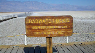
We then drove a few miles south to Badwater Basin, the lowest point in North America. We parked in the parking lot and wandered down some steps to a few wayside exhibits next to the pathetic remains of what used to be a fairly significant body of water. Pete, whose back was bothering him, had decided to stay back at the car. As he got out and walked around to stretch, he noticed that our driver's side rear tire appeared to be losing air. We quickly came back to the Tahoe and assessed the situation. We decided to try to make it back to the gas station at Furnace Creek and change the tire there.We could have used the fix-a-flat, but we had to drive all the way back to Las Vegas for our flight home, and no one wanted to be stranded on a deserted highway if the patch failed to hold.
We made it back to the gas station, and the friendly mechanic working there agreed to help us. Both Tim and Brian are good backyard mechanics, so they wanted to try to change the tire first, and the station attendant was happy to let them go at it. I had previously witnessed Brian changing a tire at the very remote Warbonnet Creek Battlefield in northwest Nebraska, so I had complete confidence that we would be fine. I sat down on a bench with Steve, and let those two go at it. After a few minutes, I noticed that they were both underneath the Tahoe, trying to get the spare tire out from under the car. I headed over and started to do little tasks, like holding tools and providing shade. For some reason, the darn tire seemed to be stuck. Tim handed me the owners manual and I tried to decipher the cryptic directions. The attendant sympathized, commenting on how each car had a different set up on where the spare was and how to release it, and the directions often did not make sense. Then, I turned the page in the owners manual and saw a diagram showing how the tire should be released, and it didn't match what Tim and Brian were trying. I showed the diagram to Tim, and he immediately said "Oh, I get it" and then climbed back under the vehicle with Brian, and lickety split they had it off. So I get an assist for turning the page, which is about the extent of my mechanical expertise.

We the summoned the attendant and he removed the leaky tire, and muscled the spare on with a neat little tool that held the spare in the air as he fit it onto the five bolts. He then used his power wrench to tighten the lugnuts, and we were ready to go. The attendant tried to to refuse our money, but then I got him to charge us $10 and I gave him $20.
We then retraced our route south and drove the Artists Drive to the Artists Palette, a one-way road through an area of hills and canyons that appeared to be carved through soft rock like chalk. There were various interesting colors in some of the formations at the Palette, where greens, blues and reds replace the burnt orange and brown of the normal landscape. However, we all seemed subdued after the experience with the tire, and no one really wanted to do much other than drive through this area.
 |
| The Artists Palette. |
We then drove north and turned east and headed up the Amargosa Range to Zabriskie Point. We saw a large functioning mine on private property hard by the National Park boundary. We parked in the lot and walked the short, quarter mile asphalt trail up to Zabriskie Point, where we got a nice overview of the other side of the soft hills we saw from the Artists Palette.
We also saw much SCE-like behavior, with people balancing precariously on fences and leaning over gorges. It really is a wonder that more people do not die in national parks every year.
 |
| View from Zabiskie Point. |
 |
| Wayside at Zabriskie Point. |
We then took the long drive to Dante's View (bypassing the dirt-roaded Twenty Mule Team Canyon on the way becasue of our paranoia of having only a leaky spare) and had a similar experience to the ride to Aquereberry Point as we ascended up a treacherous (albeit paved) road to a high eeyrie overlooking Death Valley from the east. Dante's View at 5475 feet is about 1000 feet lower than Aquereberry Point (6433 feet), but it looks down onto the Badwater Basin, so you really do get some dramatic views. We all enjoyed Dante's View, but we just did not have the same "get up & go" spirit that had animated the rest of the trip, so we soon climbed back in the Tahoe, drove out of the Park and headed to Las Vegas to catch our flights home.
 |
| Looking Down on the Badwater Basin from Dante's View. |
After we dropped off the Tahoe and donated our cooler, fix-a-flat and other sundrys in a place Hertz specially set aside for doantions, we all hustled throguh security and the check in process. Tim, Brian and I stayed together, as we had tickets on a connector to LAX and then a redeye back to Columbus. Steve tried to get an earlier flight back to San Diego, but ended up being on our flight to LAX. Pete was on Delta standby, but he snagged a flight to Detroit with a connector to Columbus in the morning. Tim, Brian and I grabbed a corner table at California Pizza Kitchen after going through secuirty, where we ordered some pizza and beer and began to relax. Soon, Steve and then Pete joined us, so we were able to have one last meal together. We laughed and joked and had a good time, realizing that this great trip had been an overwhelming success, and something that not very many guys in their 50's could pull off. After Pete peeled off, we finsished our drinks and went to the gate, where Steve and I took turns reading stories from the
Death In Yosemite book. Brian chatted with his girlfriend, and Tim meerily texted to the whole world. We four then had a nice flight to LA (I slept the whole way), and then parked ourselves at a bar in LAX that apparently is related to California Pizza Kitchen. Steve waited with us as we had more beers and some salads, and then Steve peeled off for his flight to San Diego. Tim, Brian and I trudged over to our gate for the late flight to CBus, passing Henry Winkler on the way (he smiled broadly and acknowledged our greeting, probably becasue we didn't call him The Fonz). As we sat at our gate, Ron Jeremy walked by. Only in LA.
We boarded the big bird, and then settled into our darkened seats for the cocoon-like experience that is a redeye. I was exhausted and slept fairly well. We gathered our luggage in Columbus in the morning, and I took Tim home and then Brian to my house to pick up his car. I showered, and then drove into work, trying hard to stay awake so I could get back onto eastern time. The whole day, a warm glow began to grow inside me as I remembered the events of the past nine days: the beautiful meadows, the glorious trees, the granite domes, the roaring water, and the great friends. And I knew I would never be the same again.


 Tim went to the desk and approached a guide who was standing there in the familiar blue shirt. He was a man in his forties named Mark Troup, and he was in fact our assigned guide. Tim and I explained to Mark that we wanted a general overview tour that focused on Austin, and that we would love to see things like witness trees, etchings left by soldiers and earthworks. Mark was enthused about the assignment, and commented that we were spending far more time in our introductory trip than most visitors do in their only guided tour of Gettysburg. We left to go out to my car, and Tim snapped a few more goofy photos on the way out of the VC, where a statue of Abe Lincoln repining on a bench proved to be an irresistible lure to our firefighter friend.


