We ate dinner at a Mexican restaurant in Oak Creek and then called it a night as we tried to adjust to Pacific Coast time. On Easter Sunday, we started the day late, allowing my son and his friend Eric to sleep in, and then attended Easter Mass at St. John Vianney Church in Sedona. This is a beautiful church, expertly built into the rugged landscape, with spectacular views of soaring red rock cliffs through the windows behind its altar. We arrived very early for Mass, not knowing the exact location of the church, but that gave us plenty of time to tour the numerous interesting sculptures and gardens surrounding the church. The priest led a terrific Easter service, and we all left feeling happy and full of life in the sunny, windy red rock hills.
 |
| Bell Mountain in Sedona |
We followed the signs of I-17 to the Well, and parked in a small dirt parking lot that was full to capacity. There was a small Visitor's Center (really, just a little shed) but it had a sign at the window saying that the Ranger was leading a hike. We walked up a hillside path with much informational signage about the plants and trees we were walking by, and then we topped the rise and found a very surprising view. I guess I was expecting some sort of spring releasing water into a small stream, which would have been amazing enough in this parched landscape. Instead, we were greeted with a fair sized lake in what looked like an abandoned rock quarry. Ancient cliff dwellings perched precariously in the cliffs above the water. We followed a path down to the lake level and explored more cliff dwellings at the surface level. The lake is fed by an underground aquifer, and it has carved an outlet through the limestone so that it empties in a spring that the Sinaqua Indians of the 1300's used to irrigate their fields. This water source had to be an incredible boon to their civilization in this dry area.
 |
| The lake at Montezuma's Well; note the cliff dwellings. |
We then headed one more exit south on I-17 to the Castle. This famous site has a much larger parking area, but it was also full to capacity. As we approached the Visitor's Center (a classic built in 1960 with the low, rambling ranch-style architecture, outdoor pergola and rounded lettering on signs of that period), we discovered the reason for the Parks' popularity on this Easter Sunday: the entrance fee had been waived by the NPS for these three sites. I hustled over to the large stamp station, and was delighted (or should I say dee-lighted) to find a stamp honoring Teddy Roosevelt, along with stamps for the site, the 25th anniversary of the passport program and for the 50th anniversary of the classic Visitor's Center. The museum had a nice tribute to Roosevelt's preservation record that I shared with the boys (230 million acres preserved is impressive even to a 17 year old). I bought hat pins for the Castle and Tuzigoot (because a Ranger told me that the gift store was closed at Tuzigoot), but they did not have a pin for the Well.

We then walked out of the VC and down a paved path to view the Castle. This large (4 story) dwelling is one of the best preserved cliff dwellings in the American Southwest, but you cannot tour it, which is a little disappointing. The NPS allows tours of similar (albeit smaller) structures at Mesa Verde and many other sites. We then walked down to see the remains of a dwelling built at the foot of the cliff, and then down to Wet Beaver Creek, which is a substantial watercourse at this site. We then returned to the VC and headed to our car for the trip to Tuzigoot (pronounced Two-Z-gute).

We headed north from the Castle toward Cottonwood, Arizona, through a beautiful valley framed by the Mingus Mountains towering off to the west. We were surprised to find that Cottonwood and its surrounding cities such as Clarkdale were virtual copies of suburban sprawl communities throughout the US. However, as we went past them and entered the valley where Tuzigoot is located, we entered a pristine area. Tuzigoot is a ruin of an Indian village built on a small mesa. It is not a cliff dwelling. At the VC (which was open despite what we had been told), we learned that the area to the west of the village had been a field of copper tailings from a 19th century mining operation, and that the village itself was excavated as part of a Works Progress Administration project in 1935 that was designed for "shovel ready" projects that could be implemented within 90 days. In fact, the site had a stamp honoring the WPA involvement (see above), along with the anniversary of the stamp program and the site's own stamp cancellation.
 |
| View of the Tuzigoot Ruin from the foot of the structure at the end of the mesa |
 |
| View of Tuzigoot Ruin from the top of the Ruin |
Jerome turned out to be a delight. It was a rough-n-tumble mining town of 15,000 souls that turned into a virtual ghost town of less than 200 people after the mine closed. During the 1960's, hippies, bikers and other society drop outs began to arrive in the town, which has now grown into a thriving artist's community that exists off tourism. We drove up the switchback roads into the town, grabbed a parking space and spent the late afternoon going in and out of shops and enjoying the spectacular views. We then drove east to Sedona as the sun set behind us, painting the red rock hills in fiery late afternoon hues that dazzled our Midwestern eyes. We enjoyed our seafood dinners, and then wobbled back to Oak Creek for the night.
We spent Monday hanging out at the pool of the Hilton Sedona resort and then headed into town for some shopping. However, on Tuesday, we had a Big Day: the Grand Canyon. We got the boys up early and hit the road at 7:00 am, driving up Route 89A through the spectaular Oak Creek valley from Sedona to Flagstaff. What a great drive!!

At Flagstaff, we took I-40 west to Arizona 64, which headed north to the South Rim of the Grand Canyon at the main Visitor's Center near Mather Point. The temperature was in the mid-forties, about 20 degrees cooler than Sedona. We toured the Visitor's Center and the gift shop, and then headed to Mather Point to see what all the fuss is about. It was a windy day, and there was some haze in the air, but the view was awe-inspiring, especially to my wife, son and Eric.
 |
| My Tusyan Ruin cancellation on the bottom left, squeezed in among some neat red stamps from the Dixie National Forest in Utah from a Stamp Guys trip in 2009 and a nice Sedona stamp from the Coconino National Forest that I got on this trip. |
 |
| Cancellations for Desert View, Verkamps and Kolb Studio at the Grand Canyon, along with Sunset Crater, Wupatki and Walnut Canyon (which I will describe a little later) |
 |
| My wife, son and Eric gaze at Cedar Mountain rising from the Painted Desert from the Desert View site |
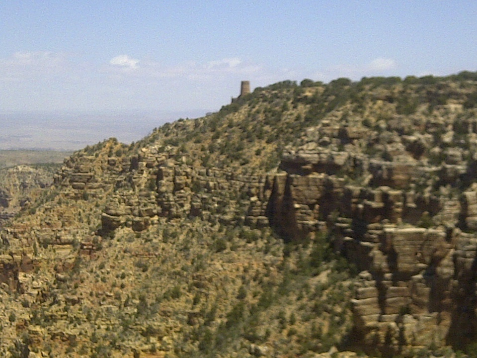
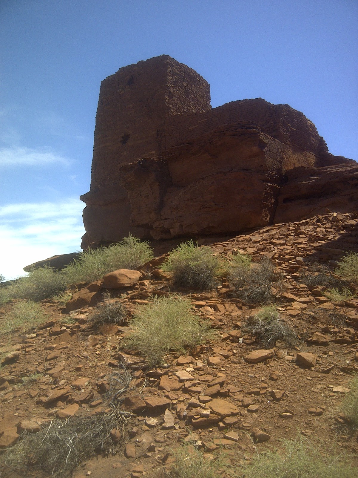
After spending about 20 minutes in the area around the Visitor's Center, we headed east to Desert View, on the edge of the park with views of both the Canyon and the Painted Desert. We passed numerous viewing points on the way to Desert View, and decided to hit them on the way back. The most famous part of Desert View is the Watchtower built in 1934 by Mary Colter. This structure is designed to resemble Native American dwellings from the area (and I would find out later in the week how much it actually does resemble them). We got to Desert View, parked the car, got the stamp and the pin, and headed out to the Watchtower. The area around the Watchtower is under construction, but the Tower itself is still open. We took in the great view of Cedar Mountain and the Painted Desert, and then headed into the Tower.
The first floor of the Tower is a gift shop, but as you ascend a flight of stairs you have a choice: go out onto an open-air porch designed to resemble a kiva, or proceed into a circular room. We took in the views from the kiva, and then entered the room . . . and Wow! The interior of the Tower is designed and painted to resemble Native American dwellings. It was like a mini-Sistine Chapel, with paintings on the ceiling three flights up, and paintings on the walls. It was terrifically cool! We ascended to the top floor, but we could not go onto the roof (even though there was a ladder there, it was closed off with a sign prohibiting any further climb). The day was very windy, and I can understand the reluctance of the NPS to allow people to get blown off the top of the Tower.
 |
| The view that greets you when you go up the steps from the Watchtower gift store. |
 |
| The ceiling of the Watchtower |
We eventually made our way down from the Tower, and then headed over to a cafeteria for a nice, inexpensive lunch prepared by NPS employees. We then left Desert View and stopped at Tusyan Ruins, our first stop on the way back to the main south rim sites that we had not yet seen. We were greeted in the Tusyan Museum by a 26 year old female ranger from Wisconsin who (in her regulation NPS green uniform and sporting the flat-brimmed Smokey Bear hat with her jet black hair sneaking out from the sides and the back) was about the cutest human being you can possibly imagine. She told us that she would be leading a guided tour out to the ruins in about 15 minutes, and that we could tour the Museum in the meantime while we waited. She then ooh-ed and ah-ed over my Passport as I got my stamp, further ingraining herself in my good graces. The Museum was small but very cool: the walls were covered with various descriptions of the 21st century lives of the Indian tribes of Northern Arizona, while the interior of the museum contained artifacts left by their Indian ancestors who had lived at this site (including a flint spear point that is 12,000 years old).
Our Ranger friend then led a small group of folks on a tour of the ruins. Our tour group included people from Canada, Australia, the Czech Republic (and of course Ohio and Wisconsin). Our guide did a nice job asking questions to get people to think about the ruins in a 13th Century mindset, and explained the abreviated life spans of the inhabitants (married at 13, dead by their mid-30's). She showed us the remains of houses and kivas. She explained farming methods and water storage techniques. She also focused on the spirtual aspects of being near the Grand Canyon (where the Indians' creation myth had the ancient ancestors emerging from their underground paradise onto the surface--kind of a similar diaspora from the Garden of Eden in Western theology) and within viewing of the spectacular San Francisco Peaks, hovering directly to the south, 90 miles distant with their snow-capped crowns gleaming in the rapidly clearing air of the day.
We left Tusyan and proceeded to various spectacular South Rim viewing spots such as Navajo Point (with a great view of the nearby Watchtower, rendered tiny by the immensity of the landscape) and Lipan Point, which afforded a view to the west of the mile-long Hance Rapids of the Colorado River. These spots were rapidly filling up as the mist cleared from the air, and we struggled to find parking as we moved farther west. Finally, we decided to head to the historic Kolb Studio area, where a 2:00 pm Condor Talk was being sponsered by the Park Service. We parked near the Verkamp Visitor's Center (well, as near as the public can park) and then double-timed our way to the Kolb Studio in order to make the talk on time.
 |
| A view of the Desert View Watchtower from Navajo Point. |
The Condor Talk featured a 27 year old female Ranger, who (at 5'2") was about two inches shorter than our Tusyan Ranger, but did not fall short of our Cheesehead friend on either knowledge or the cute-as-a-button scale (she wore her long black hair in a ponytail out the back gap of an NPS ball cap). This Ranger led a spirited 45 minute discussion on the California Condor, and told us how to distinguish the 73 Condors in the park (out of 369 in the world) from ravens and vultures. She told us that Condors were such magnificent gliders that they could cross the entire ten mile breadth of the Grand Canyon without flapping their wings once. She explained the captive breeding program insituted in the 1990's that brought the condors (reduced to a mere handfull of 20 birds in the world) back from the edge of extinction, and explained how hunting in Northern Arizona was actually a benefit to the Condors (who are scavengers) but only if the hunters can be convinced to switch from lead ammunition to copper-jacketed slugs, lead poisoning being terrifically bad for the eggs of baby condors.
After the presentation, we ducked into the Kolb Studio (where I got yet another stamp and pin!) and enjoyed the exhibits on the amazing Kolb brothers, who not only produced many of the earliest iconic photographs of the canyon, but also started rafting tours down the Colorado River and established many of the south rim trails. They also were darn good businessmen, keeping their studio afloat from the early decades of the 20th Century until the Park Service bought the last brother out in the 1970's.
As we emerged from the Kolb Studio, my wife paused to take some pictures of the private gate the Kolbs used to enter the Bright Angel trail. As she adjusted her lense, I gazed at the sky over the Canyon--and spotted a California Condor!!! I quickly pointed out the gliding bird, who rapidly grew larger as he swept toward the South Rim. The bird turned east just before he flew over our heads, and we had a clear view of his bald head and white underfeathers on his 8 foot wingspan. We excitedly followed the condor to the east, where he perched on a rock ledge just below the Tonti Hotel site. The folks from the Condor talk were still milling about, and they had also caught a view of the condor as he wheeled past them. A fairly large crowd of folks descended on the railings along the rim, gazing in awe at this magnificent creature. Our avian friend basked in the attention of the multitudes, preening and showing off his feathers as he presented them to the westing Sun for warmth on the windy day.
We made our way east toward the Verkamp's Visitors Center, which is in the heart of the historic South Rim tourist district, lodged in a former general store run by a guy called Verkamp. I got my last stamp of the day, along with a Verkamps pin and a Condor pin. The boys were starting to get a little bored, so we decided to pack it in and drive back to Sedona while we still had light. We really enjoyed the views of the San Francisco Peaks outside Flagstaff and then the wonderous drive down into the Oak Creek valley on I-17 as the setting sun cast its ruby palette over the Red Rock country.
On Wednesday, we took a jeep tour from Sedona up the dirt Schnebly Hill Road to the top of the Mogollon Rim, ascending 3000 feet as our jeep creeped along the rim of the valley. Our guide was Mario Henry Black Bear, a surly Apache (he prefers to be called a Michi-ta, the Apache word for "the people" because the word "apache" is actually an insult in their language!) with a treasure trove of knowledge about the history, geology, flora & fauna, and animals of the Sedona area. We enjoyed Mario immensely, but we did cross some of his peculiar social barriers from time to time and had to be scolded (which prompted my determiend wife to scold back, because you shouldn't be scolded for crossing barriers you don't know exist). Talk about the immovable object meeting the irresistable force.
On Thursday, my wife and I awoke early and got ready to go to the Flagstaff area to visit the three national monuments near that alpine town. However, the boys rolled around in their teenage-boy sleeping stupor and said they would rather sleep than see the sites. My wife decided that she would stay with them and grade some of her fourth graders papers, so I was accorded a day on my own to visit the sites and get some stamps.
My first stop was Sunset Crater Volcano National Monument, about 25 miles northeast of Flagstaff. I got to the VC about ten minutes before it opened at 9:00 am, so I visited some nearby waysides and learned that the San Francisco Peaks, which loom over the park, are really the remains of one huge mountain that was a volcano, and are part of the same volcanic field that produced a series of eruptions at Sunset Crater between 1050 and 1200 A.D. I then went to the VC, which had a full house of tourists. I was greeted by a middle-aged Native American female Ranger, who watched me stamp my Passport and then whipped out the park brochure and told me where I needed to go. She instructed me to take various trails and hikes ("I can tell that you'll like them"). She then asked if I planned on visiting Wupatki National Monument, which is actually on the same road that winds thru Sunset Crater. When I told her I was all in, she then instructed me what to visit on the way from Sunset Crater to Wupatki. I obediantly listened to her instructions and followed them to a "T" and boy, am I glad I did.
 |
| From the Cinder Hills Overlook |
I drove a short distance from the VC and stopped at the Lenox Crater Trail. The roadside parking lot for the Trail provided a view of a lava field, where twisted black rocks dominated the landscape, looking like they had been left there yesterday. The Trail was only a quarter mile long, but it basically went straight up a 300 foot incline, and it was made up of spongy gravel similar to sand. If you are a fat flatlander, hiking up a 300 foot incline through soft gravel at 7000 feet of altitude robs you of your breath rather quickly. However, with a couple of stops to gasp and regain some wind, I eventually made it to the top of the trail, and looked into the Lenox Crater, which is one of the craters created by a lesser explosion of the volcano. It was enormous, and the entire bowl looked like a paved parking lot, but it was actually smoothed out lava, melted from its originally craggy form by the heat of subsequent eruptions. As I looked around, I spied a beautiful view into the actual main crater of Sunset Crater Volcano, bereft of all foliage, gleaming red in the morning light.
I returned down the steep path, greeting fellow hikers who were making their way slowly up to the summit, and then drove to the next stop: the Lava Flow Trail. This trail allows you to walk through the Bonita Lava Flow field, which is formed just below the main crater. It is a simple one mile loop trail, but it leads you through some of the most fantastic landscape I have ever seen. Twisted formations of dark black lava are everywhere you look. The red, bare hillside of Sunset Crater looms before you, while the snow-capped San Francisco Peaks peer over your shoulder. Some Ponderosa Pine and other hardy desert plants grow, but it is an area dominated by black rock. At the end of the trail, there is an incongrous hillock of red dirt and stone sitting amid the tumbled black lava. A sign explains that this is the former top of the mountain (the magma cap), blown sky high by the explosion and landed here. Another sign explains that you are walking near the area (the crater itself) that the native Americans of the southwest tribes believe their Kachinas return to the underworld. Wow!
I then climbed back into my car, thrilled by the sites I was seeing. I drove to the Cinder Hills Overlook, which gives you a great view of the main crater (see picture above). I then drove out of the Monument and toward Wupatki, admiring the greenery of the alpine country that makes up Sunset Crater before stopping at the Painted Desert Vista, as instructed by the Ranger at the VC. This stop gives you a view of another lava flow, and beyond it, the greenery abrubtly stops as the Painted Desert begins, and stretches off to the north and east, with large mesas visible in the distance. Did I say Wow and thrilled? I literally thanked God for letting me see such a gorgeous site.
I then continued on the loop road for about 20 miles, always dropping in altitude and gradually entering the Painted Desert. I took a right turn at a road marked for the Wahooki Ruins, as instructed by my Ranger, even though I could see the Wupatki Visitor's Center looming about a half mile away down the main road. I had learned to trust the Sunset Crater Ranger, and she didn't steer me wrong here either.
 |
| The Wahooki ruins, from the bottom of the dry wash along its northern side. |
The two mile road ended in a small parking lot. As I stepped out of my car, I saw the Ruins: a couple of stacked stone strucutres built on a natural rock outcropping overlooking a broad, deep dry wash. I walked up to, in and around the ruins with several other tourists. Nothing was off limits. What a great place!
I then headed back up the road to the Wupatki VC, got my stamps (see above) and a pin, and took in a nice display in the VC museum about the founding of the Monument. It seems that a Navajo family was occupying the ruins at the time the first NPS Ranger was sent to Wupatki, so he simply moved in with them and became their close friend. He proposed (by letter) to a fellow Ranger, and she moved out from Chicago, and set up housekeeping in the ruin, where their son was born. The son and the youngest male Navajo became friends, and the Navajo eventually became an NPS Ranger at the site. All this text was accompanied by great photos illustrating these 1930's stories.
I then walked out of the modern VC (which is built next to the houses built for the Rangers when they moved out of their accommodations in the Ruins), and beheld the majestic site of a large, excavated village of homes, storage places and kivas, built in stack-stone fashion on a large natural rock outcropping. Next to the excavation, there was an unexcavated portion of another large home, and then, down in the valley next to the outcropping, a stone-ringed circular area, and farther down the hill a stone-ringed box-shaped area next to a small stone-covered area that looked like a forlorn patio in the middle of nowhere.
 |
| The main portion of the Wupatki Ruin. |
I followed the trail, using a guidebook I had purchased for $1.00 in the VC. I learned that the village had been built and expanded over a period of about 30 years, that the circular area farther down the hill was a plaza used for the trading of goods with other tribes and that the box-shaped area was actually a ball field used to play a game similar to street hockey. Most interestingly, the forlorn patio was the cover for a blowhole, a geologic feature through which the inner reaches of the Earth's crust inhales and exhales, dependent upon the external air pressure and temperature. These blowholes are fairly rare, and the site of this one may have been determinative in the placement of the Wupatki Village, especially for people who believed that their ancestors originated in life under the Earth's surface.
I then drove to the four remaining ruins in the Monument: Citadel, Box Canyon, Nalakihu and Lomaki, which are farther down the loop road as you near the end of the intersection with Route 89A. Citadel is a rounded, fort-like strucure, but the rest are similar stack-stone, squarish dwellings. The neat thing about them is their setting. Lomaki has grasslands surrounding it, and the Painted Desert in the distance beyond; Box Canyon Ruins are two different strucutres, one on each arm of a narrow but deep box canyon that is about two stories tall, with the San Francisco Peaks gleaming in the background.
 |
| Box Canyon Ruins |
With this gorgeous memory of Wupatki National Monument lingering in my mind, I wheeled the Expedition out onto Route 89A and headed south for Walnut Canyon National Monument, which sits just east of Flagstaff. I arrived there at approximately 1:30 pm, and the wind was howling as I approached the VC. I got my stamp (see above) and pin. Yet another female Native American Ranger greeted me (this Ranger being a bit more willowy than the round-faced lady who guided me so well at Sunset Crater) and told me about the tour: 285 steps down to the ruins in the midpoint of the 600 foot deep canyon, 285 steps back up; take a full 45 minutes; don't rush; drink water; and please don't have a heart attack. And, oh yeah; have fun!
 |
| Please see the "windows" that help locate the structures in the yellow limestone layer of rock about half-way down the steep wall of Walnut Canyon |
I then walked out of the VC, into the wind, and began my descent. The wind quickly abated as I went farther down the stairs; the Canyon is very steep and very narrow. Unfortuantely, the creek that formed the Canyon no longer flows through it; the City of Flagstaff dammed it in 1906 to create a reservior. Because of this action, the Canyon is drier today than it was in the 12th and 13th centuries, and when it was named "Walnut Canyon" for the black walnut trees that proliferated there in the 19th century. Without the riverine environment, there are very few black walnut trees left in Walnut Canyon. Happily, however, there are many majestic old growth Douglas Firs that were not harvested because of the difficult topography of the Canyon.
I eventually made it to the bottom of the steps, which is about halfway down the cliff into the Canyon. There, I was greeted by a NPS volunteer Ranger, a woman from New York in her sixties who had recently retired to the Flagstaff area. She was very nice and informative (witness my knowledge of the lack of black walnut trees). She escorted me as I walked along the ruins, which were built in the areas below the hard stone layers where the soft limestone eroded, leaving a nice hard roof overhang and a naturally dug out cave-like structure that runs horizontially along the cliff.

There was very little space between the dwellings and the edge of the cliff, so the Indians built some retaining walls to help keep people and animals from tumbling 300 feet down a sheer rock cliff into a raging stream. The volunteer Ranger explained that the Indians grew their crops on the flat tableland surrounding the Canyon, and fished in the creek below. All I have to say is that they led a very tough life. They did not have a nice set of concrete stairs with a metal railing to guide their access and egress to their homes. I cannot imagine raising children on the lip of a 300 foor cliff. They must have faced some fearsome predators on the surface above to be willing to endure these dangers in the Canyon.
I then returned to Sedona, where we had a nice dinner at the M Diamond Ranch (after a horseback ride), where we watched a beautiful desert sunset. We climbed Bell Mountain on Friday and then returned to Ohio on Saturday.